IMAGES TAKEN NEAR TO
George Thomas Avenue, BRIDGEND, CF32 9SQ
Introduction
This page details the photographs taken nearby to George Thomas Avenue, CF32 9SQ by members of the Geograph project.
The Geograph project started in 2005 with the aim of publishing, organising and preserving representative images for every square kilometre of Great Britain, Ireland and the Isle of Man.

There are currently over 7.5m images from over14,400 individuals and you can help contribute to the project by visiting https://www.geograph.org.uk
Image Map
Images are licensed for reuse under creativecommons.org/licenses/by-sa/2.0
Notes
- Clicking on the map will re-center to the selected point.
- The higher the marker number, the further away the image location is from the centre of the postcode.
Image Listing (86 Images Found)
Images are licensed for reuse under creativecommons.org/licenses/by-sa/2.0
Image
Details
Distance
1
Brynmenyn
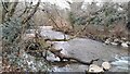
Brynmenyn, Ogmore river view upriver
Image: © Colin Prosser
Taken: 12 Feb 2023
0.05 miles
2
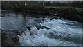
Brynmenyn
Brynmenyn, the weir river Ogmore, just off the cycletrack by the former Brynmenyn railway station
Image: © Colin Prosser
Taken: 2 Jan 2021
0.05 miles
3
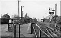
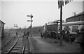
Brynmenyn Station
View SW, towards Tondu and Pyle; ex-Great Western lines, Bridgend and Pyle via Tondu to Blaengarw by the Garw Branch (closed to passengers 9/2/53, still open 2010 - but disused [?] - as far as Pontycymer), and via the Blackmill Branch to Nantymoel (Ogmore Branch, closed to passengers 5/5/58, remainder open for coal from Ogmore Washery but in 2010 is mothballed). Also trains ran until 22/9/30 through Brynmenyn via Blackmill by the Gilfach Branch via Hendreforgan to Gilfach Goch and until 5/6/61 goods ran by the Hendreforgan Branch to Gellyrhaiad Junction on the Ely Valley Line (Taff Vale Rly.).
Image: © Ben Brooksbank
Taken: 1 Jun 1962
0.06 miles
4
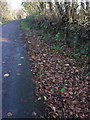
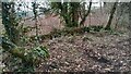
Disused platform at Brynmenyn Junction
The old platform is slowing being reclaimed by Nature
Image: © John Finch
Taken: 7 Dec 2011
0.07 miles
5
Brynmenyn
Brynmenyn, the brickwork is what remains of the former signal box at Brynmenyn railway station
Image: © Colin Prosser
Taken: 12 Feb 2023
0.07 miles
6
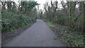
Brynmenyn
Brynmenyn, cycletrack, this was formerly Brynmenyn railway station, with view direction towards Tondu, the stone walls are still visible where the platforms were, just behind the bushes to the right, was the platform which led trains up down the Garw Valley
Image: © Colin Prosser
Taken: 2 Jan 2021
0.07 miles
7

Brynmenyn
Brynmenyn, disused railway, the stonework can still be seen clearly which was the old platform, which was the railway from Brynmenyn to Ogmore Vale, also Gilfach, it is now a cycle track and footpath
Image: © Colin Prosser
Taken: 3 Jan 2022
0.07 miles
8
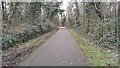
Brynmenyn
Brynmenyn former railway station, the platform stonework still visible, now a cycle track and pedestrian way to the Ogmore Valley
Image: © Colin Prosser
Taken: 12 Feb 2023
0.07 miles
9
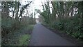
Brynmenyn
Brynmenyn, now a cycletrack, this was formerly Brynmenyn railway station, the stone walls are still visible where the platform was, which would have taken trains the direction view towards the Ogmore Valley, Gilfach Valley, Heol y Cyw and Brynna
Image: © Colin Prosser
Taken: 2 Jan 2021
0.08 miles
10
Railtour at Brynmenyn Station
Brynmenyn was the junction for steeply graded lines up the Garw & Ogmore valleys & at one time had 4 platforms! On the right the DMU railtour is about to travel up the Garw valley line to Blaengarw. It was opened to goods traffic in 1876 but not until 1902 for passenger traffic. Closure to passengers came in 1953. Coal traffic ended post-2000 but more recent photos on geograph suggest the track might have been left in place. The train will subsequently return & travel up the Ogmore valley line on the left to Nantymoel. This was opened to goods in 1865 & passengers in 1873. Closure to passenger traffic came in 1958 & finally to coal traffic in 1989. Notable is the station nameboard - 9 years after the last passenger needed it!
Ben Brooksbank's 1962 photo Image was taken from the far end of the Garw valley line platform. In both photos the signal box can be seen.
The railtour, 'South Wales Valley Tour No.1', was an extensive & fascinating ramble along many goods-only branch lines marred only by the miserable weather. Details of the route can be found on the Six Bells Junction website http://www.sixbellsjunction.co.uk/ .
Image: © Martin Tester
Taken: 14 Oct 1967
0.08 miles