IMAGES TAKEN NEAR TO
Highfield Place, BRIDGEND, CF32 9RR
Introduction
This page details the photographs taken nearby to Highfield Place, CF32 9RR by members of the Geograph project.
The Geograph project started in 2005 with the aim of publishing, organising and preserving representative images for every square kilometre of Great Britain, Ireland and the Isle of Man.

There are currently over 7.5m images from over14,400 individuals and you can help contribute to the project by visiting https://www.geograph.org.uk
Image Map
Images are licensed for reuse under creativecommons.org/licenses/by-sa/2.0
Notes
- Clicking on the map will re-center to the selected point.
- The higher the marker number, the further away the image location is from the centre of the postcode.
Image Listing (103 Images Found)
Images are licensed for reuse under creativecommons.org/licenses/by-sa/2.0
Image
Details
Distance
1
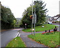
Junction of Wern Ddu and Sarn Hill, Sarn
Wern Ddu from the right joins Sarn Hill.
Image: © Jaggery
Taken: 11 Oct 2018
0.07 miles
2
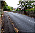
Steep ascent, Sarn Hill, Sarn
Sarn Hill ascends towards the centre of Sarn.
Image: © Jaggery
Taken: 11 Oct 2018
0.07 miles
3
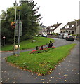
Grass triangle, Wern Ddu, Sarn
On the corner of Sarn Hill and the cul-de-sac Wern Ddu.
Image: © Jaggery
Taken: 11 Oct 2018
0.07 miles
4
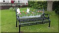
Sarn cemetery
Sarn cemetery, newly added bench, to commemorate men and women who fell during both wars 1914 to 1918 and 1939 to 1945, there has been added a 2nd bench, one each side of the plaque
Image: © Colin Prosser
Taken: 18 May 2021
0.08 miles
5
Sarn cemetery
Sarn cemetery, new plaque to commemorate men and women who fell during the wars 1914 to 1918 and 1939 to 1945
Image: © Colin Prosser
Taken: 18 May 2021
0.08 miles
6
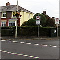
Telecoms cabinets on a Sarn corner
Dark green cabinets alongside the dark green hedge on the corner of Heol Pentyla and Heol Ganol.
Image: © Jaggery
Taken: 11 Oct 2018
0.09 miles
7
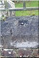
Ordnance Survey Rivet
This OS rivet can be found on the wall of the cemetery on Sarn Hill. It marks a point 61.749m above mean sea level.
Image: © Adrian Dust
Taken: 29 Sep 2021
0.09 miles
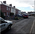
8
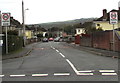
Heol Pentyla, Sarn
The 30mph speed limit on Heol Ganol drops to 20mph on Heol Pentyla.
Image: © Jaggery
Taken: 11 Oct 2018
0.10 miles
9
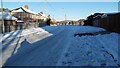
Sarn
Sarn, The Green, when snowfall from a week earlier, had frozen and turned to ice
Image: © Colin Prosser
Taken: 25 Dec 2010
0.11 miles
10
Heol Fain, Sarn
Looking along Heol Fain from the Bryncoch Road end.
Image: © Jaggery
Taken: 10 Oct 2014
0.12 miles