IMAGES TAKEN NEAR TO
Maes Brynach, BRIDGEND, CF32 9PT
Introduction
This page details the photographs taken nearby to Maes Brynach, CF32 9PT by members of the Geograph project.
The Geograph project started in 2005 with the aim of publishing, organising and preserving representative images for every square kilometre of Great Britain, Ireland and the Isle of Man.

There are currently over 7.5m images from over14,400 individuals and you can help contribute to the project by visiting https://www.geograph.org.uk
Image Map
Images are licensed for reuse under creativecommons.org/licenses/by-sa/2.0
Notes
- Clicking on the map will re-center to the selected point.
- The higher the marker number, the further away the image location is from the centre of the postcode.
Image Listing (23 Images Found)
Images are licensed for reuse under creativecommons.org/licenses/by-sa/2.0
Image
Details
Distance
1
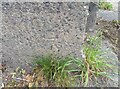
Ordnance Survey Cut Mark
This OS cut mark can be found on the NE parapet of Abergarw Bridge. It marks a point 56.912m above mean sea level.
Image: © Adrian Dust
Taken: 5 Sep 2021
0.13 miles
2
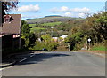
Ogmore Terrace, Bryncethin
North along Ogmore Terrace towards the A4065 and Abergarw.
Image: © Jaggery
Taken: 29 Oct 2018
0.14 miles
3
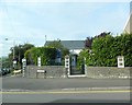
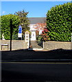
Gateway to Nazareth Baptist Chapel, Bryncethin
Image: © John Lord
Taken: 1 Sep 2013
0.18 miles
5
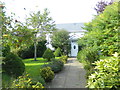
Entrance to Nazareth Baptist Chapel, Bryncethin
From the north side of Wigan Terrace near the corner of Ogmore Terrace.
Image: © Jaggery
Taken: 29 Oct 2018
0.18 miles
6
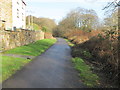
Celtic Trail heading towards Blackmill
Leaving Brynmenyn and heading along the Ogmore Valley.
Image: © John Light
Taken: 13 Jan 2012
0.18 miles
7
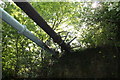
Pipes over the Ogmore cycle track in Brynmenyn
Image: © Paul Whippey
Taken: 29 Apr 2011
0.19 miles
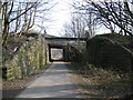
8
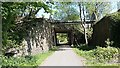
Brynmenyn
Brynmenyn to Blackmill disused railway and overhead road bridge, now a cycletrack
Image: © Colin Prosser
Taken: 22 Apr 2020
0.19 miles
9
Abergarw road bridge over GWR trackbed
Trackbed now a cycle track,looks like original bridge has been replaced
Image: © Ray Durrant
Taken: 10 Apr 2013
0.19 miles
10
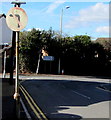
No Left Turn sign, Wigan Terrace, Bryncethin
Faded in October 2018, the sign faces westbound traffic on the approach to the Ogmore Terrace junction.
In the background, a sign alongside Ogmore Terrace shows All Traffic and the Welsh Pob Cerbyd.
Image: © Jaggery
Taken: 29 Oct 2018
0.20 miles