IMAGES TAKEN NEAR TO
Abergarw Road, BRIDGEND, CF32 9LF
Introduction
This page details the photographs taken nearby to Abergarw Road, CF32 9LF by members of the Geograph project.
The Geograph project started in 2005 with the aim of publishing, organising and preserving representative images for every square kilometre of Great Britain, Ireland and the Isle of Man.

There are currently over 7.5m images from over14,400 individuals and you can help contribute to the project by visiting https://www.geograph.org.uk
Image Map
Images are licensed for reuse under creativecommons.org/licenses/by-sa/2.0
Notes
- Clicking on the map will re-center to the selected point.
- The higher the marker number, the further away the image location is from the centre of the postcode.
Image Listing (53 Images Found)
Images are licensed for reuse under creativecommons.org/licenses/by-sa/2.0
Image
Details
Distance
1
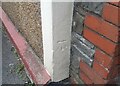
Ordnance Survey Cut Mark
This OS cut mark can be found on the Council Offices on Abergarw Road. It marks a point 52.130m above mean sea level.
Image: © Adrian Dust
Taken: 5 Sep 2021
0.03 miles
2
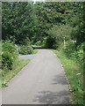
National Cycle Route 4 at Brynmenyn
A photograph taken on the three mile section between Blackmill and Sarn where the long distance cycle route passes along a stretch of the path making up the Ogmore Valley Community Route.
A colourful milepost is seen, side on, to the right of the path. Image provides a closer view of it.
Image: © eswales
Taken: 5 Aug 2011
0.04 miles
3
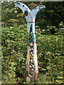
Millennium milepost beside National Cycle Route 4, Brynmenyn
A milepost situated beside a combined cycle and footpath which is followed by the Ogmore Valley Community Route as well as National Cycle Route 4. Of the four designs which the millennium mileposts of the National Cycle Network may have, this is an example of the Fossil Tree.
The milepost indicates 3 miles to Bridgend and 2 miles to Blackmill.
Image: © eswales
Taken: 5 Aug 2011
0.04 miles
4
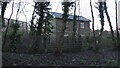
Brynmenyn
Brynmenyn, view off the cycletrack, which was the former railway from Brynmenyn to Ogmore Vale, the house was a former railwayman's house
Image: © Colin Prosser
Taken: 2 Jan 2021
0.06 miles
5
Brynmenyn
Brynmenyn, disused railway bridge over the river Garw, opposite side of road to the pub Fox and Hounds
Image: © Colin Prosser
Taken: 3 Jan 2022
0.08 miles
6
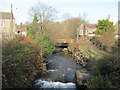
Afon Garw at Brynmenyn
In the distance is the bridge carrying the A4065.
Image: © John Light
Taken: 13 Jan 2012
0.08 miles
7
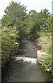
The Afon Garw/River Garw at Brynmenyn
A view upstream at a point just to the north of the river's confluence with the Ogmore.
Image: © eswales
Taken: 5 Aug 2011
0.08 miles
9
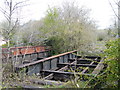
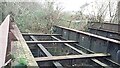
Old railway bridge
Garw valley branch line over Afon Garw,Great Western Railway
Image: © Ray Durrant
Taken: 16 Apr 2012
0.08 miles
10
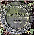
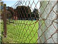
Boundary marker
Metal plate marking the boundary of the Great Western Railway Companies at Brynmenyn.
Image: © Alan Hughes
Taken: 25 Jan 2020
0.08 miles