IMAGES TAKEN NEAR TO
Bryn Gors, BRIDGEND, CF32 9HR
Introduction
This page details the photographs taken nearby to Bryn Gors, CF32 9HR by members of the Geograph project.
The Geograph project started in 2005 with the aim of publishing, organising and preserving representative images for every square kilometre of Great Britain, Ireland and the Isle of Man.

There are currently over 7.5m images from over14,400 individuals and you can help contribute to the project by visiting https://www.geograph.org.uk
Image Map
Images are licensed for reuse under creativecommons.org/licenses/by-sa/2.0
Notes
- Clicking on the map will re-center to the selected point.
- The higher the marker number, the further away the image location is from the centre of the postcode.
Image Listing (54 Images Found)
Images are licensed for reuse under creativecommons.org/licenses/by-sa/2.0
Image
Details
Distance
1

Up Penybryn Road from Brynmenyn towards Bettws
Penybryn Road ascends from the A4065 Bryn Road in Brymenyn
towards the village of Bettws about 2.5km (a mile and a half) ahead.
Image: © Jaggery
Taken: 2 Dec 2017
0.06 miles
2

Ascent from Brynmenyn towards Bettws
Penybryn Road ascends from the A4065 Bryn Road in Brymenyn towards
the village of Bettws about 2.5km (a mile and a half) ahead.
Image: © Jaggery
Taken: 2 Dec 2017
0.06 miles
3
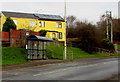
Yellow houses behind a Bryn Road bus stop and shelter, Brynmenyn
The houses are above the corner of Bryn Road and Penybryn Road.
Image: © Jaggery
Taken: 2 Dec 2017
0.07 miles
4

Bettws direction and distance sign, Bryn Road, Brynmenyn
Facing the A4065 Bryn Road on the approach to the Penybryn Road junction. https://www.geograph.org.uk/photo/5617555
Image: © Jaggery
Taken: 2 Dec 2017
0.08 miles
5
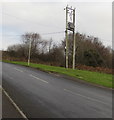
Line spur pole above a Brynmenyn corner
The Western Power Distribution line spur pole is alongside
Penybryn Road above the corner of the A4065 Bryn Road in Brynmenyn.
Image: © Jaggery
Taken: 2 Dec 2017
0.08 miles
6
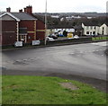
Junction at the bottom of Penybryn Road, Brynmenyn
At the end of the long descent from the village of Bettws, turn left into
the A4065 Bryn Road for Bryncethin and Bridgend. Turn right for Aberkenfig and Tondu.
Image: © Jaggery
Taken: 2 Dec 2017
0.09 miles
7
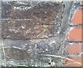
Ordnance Survey Cut Mark
This OS cut mark can be found on the wall of No168 Bryn Road. It marks a point 58.878m above mean sea level.
Image: © Adrian Dust
Taken: 5 Sep 2021
0.09 miles
8
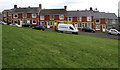
Williams Terrace, Brynmenyn
Row of houses below the A4065 Bryn Road.
Image: © Jaggery
Taken: 2 Dec 2017
0.10 miles
9
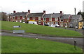
Williams Terrace, Brynmenyn
Row of houses below the A4065 Bryn Road.
Image: © Jaggery
Taken: 2 Dec 2017
0.10 miles
10
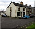
The Beauty Lounge, 147 Bryn Road, Brynmenyn
At the eastern end of houses below the A4065. http://www.geograph.org.uk/photo/5617504
Image: © Jaggery
Taken: 2 Dec 2017
0.11 miles