IMAGES TAKEN NEAR TO
Lon Derw, BRIDGEND, CF32 9FD
Introduction
This page details the photographs taken nearby to Lon Derw, CF32 9FD by members of the Geograph project.
The Geograph project started in 2005 with the aim of publishing, organising and preserving representative images for every square kilometre of Great Britain, Ireland and the Isle of Man.

There are currently over 7.5m images from over14,400 individuals and you can help contribute to the project by visiting https://www.geograph.org.uk
Image Map
Images are licensed for reuse under creativecommons.org/licenses/by-sa/2.0
Notes
- Clicking on the map will re-center to the selected point.
- The higher the marker number, the further away the image location is from the centre of the postcode.
Image Listing (77 Images Found)
Images are licensed for reuse under creativecommons.org/licenses/by-sa/2.0
Image
Details
Distance
1
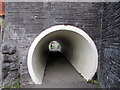
Through a pedestrian tunnel, Bryn Road, Tondu
On the east side of this bridge. http://www.geograph.org.uk/photo/5621212
Image: © Jaggery
Taken: 2 Dec 2017
0.04 miles
2

South side of Bryn Road railway bridge, Tondu
Headroom 12' 9" is shown on the rusty side of the bridge over the A4065 Bryn Road.
There are no pavements under the bridge. Walkers can use the tunnel on the right. http://www.geograph.org.uk/photo/5621213
Image: © Jaggery
Taken: 2 Dec 2017
0.04 miles
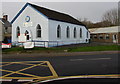
3
Ynysawdre Community Centre, Tondu
Viewed across the A4065 Bryn Road.
Image: © Jaggery
Taken: 10 Oct 2014
0.04 miles
4
Ynysawdre Community Centre, Tondu
Viewed across the A4065 Bryn Road from the corner of Heol-yr-ysgol.
Built as a Mission Hall c1900. Bryn Road Chapel is on the right. http://www.geograph.org.uk/photo/5620902
Image: © Jaggery
Taken: 2 Dec 2017
0.04 miles
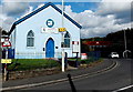
5
Bryn Road Chapel, Tondu
On the west side of the A4065 Bryn Road near a railway bridge. Ynysawdre Community Centre http://www.geograph.org.uk/photo/5620931 is on the left.
Image: © Jaggery
Taken: 2 Dec 2017
0.05 miles
6
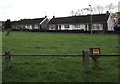
Bungalows in Brynmenyn
Located between Bryn Road and Haulfryn. A marker for an underground gas pipeline is in the foreground.
Image: © Jaggery
Taken: 2 Dec 2017
0.05 miles
7
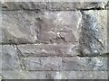
Ordnance Survey Cut Mark
This damaged OS cut mark can be found on the west buttress of the railway bridge on Bryn Road. It marks a point 45.504m above mean sea level.
Image: © Adrian Dust
Taken: 5 Sep 2021
0.05 miles
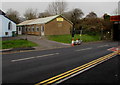
8
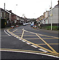
Yellow markings at a Tondu junction
At the junction of the A4065 Bryn Road and Heol-yr-ysgol on the left viewed in December 2017.
No yellow markings were here in a May 2016 Google Earth Street View.
Image: © Jaggery
Taken: 2 Dec 2017
0.05 miles
9
Houses at the eastern end of Andrews Close, Tondu
Andrews Close is on the north side of the A4065 Bryn Road.
Image: © Jaggery
Taken: 10 Oct 2014
0.06 miles
10
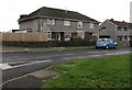
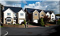
Haulfryn houses, Brynmenyn
Haulfryn is a cul-de-sac on the south side of the A4065 Bryn Road.
Image: © Jaggery
Taken: 2 Dec 2017
0.07 miles