IMAGES TAKEN NEAR TO
Williams Crescent, BRIDGEND, CF32 9EJ
Introduction
This page details the photographs taken nearby to Williams Crescent, CF32 9EJ by members of the Geograph project.
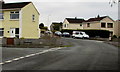
The Geograph project started in 2005 with the aim of publishing, organising and preserving representative images for every square kilometre of Great Britain, Ireland and the Isle of Man.

There are currently over 7.5m images from over14,400 individuals and you can help contribute to the project by visiting https://www.geograph.org.uk
Image Map
Images are licensed for reuse under creativecommons.org/licenses/by-sa/2.0
Notes
- Clicking on the map will re-center to the selected point.
- The higher the marker number, the further away the image location is from the centre of the postcode.
Image Listing (35 Images Found)
Images are licensed for reuse under creativecommons.org/licenses/by-sa/2.0
Image
Details
Distance
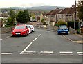
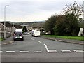
2
Two Daleside junctions, Bryncethin
The Pen y Bryn View junction is on the left. The Glen junction is ahead on the right.
Image: © Jaggery
Taken: 11 Oct 2018
0.16 miles
3
Penybryn View, Bryncethin
Cul-de-sac on the east side of Daleside.
Image: © Jaggery
Taken: 11 Oct 2018
0.19 miles
4
Bakers Way, Bryncethin
The southern end of Bakers Way viewed across Heol Canola.
Image: © Jaggery
Taken: 11 Oct 2018
0.20 miles
5
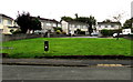
Pen y Bryn View houses, Bryncethin
Viewed across a green on the south side of Daleside.
Image: © Jaggery
Taken: 11 Oct 2018
0.20 miles
6
Eustace Drive, Bryncethin
The southern end of Eustace Drive viewed across Heol Canola.
Image: © Jaggery
Taken: 11 Oct 2018
0.20 miles
7
Leyshon Way, Bryncethin
Cul-de-sac on the north side of Daleside.
Image: © Jaggery
Taken: 11 Oct 2018
0.20 miles
8
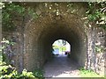
Tunnel under the Bryncethin Branch railway
The footbridge under the derelict railway at Ty'n-y-coed Junction on the Bryncethin branch Railway.
Image: © Trevor Edward Streeter
Taken: 7 May 2020
0.21 miles
9
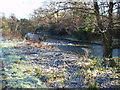
River Ogmore
A frosty view of the Ogmore from the cycle track at Ynysawdre
Image: © John Finch
Taken: 5 Jan 2003
0.21 miles
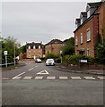
10
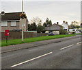
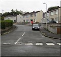
Queen Elizabeth II postbox, Heol Canola, Bryncethin
The corner of Eustace Drive is ahead.
Image: © Jaggery
Taken: 11 Oct 2018
0.21 miles