IMAGES TAKEN NEAR TO
Riverside, BRIDGEND, CF32 9DA
Introduction
This page details the photographs taken nearby to Riverside, CF32 9DA by members of the Geograph project.
The Geograph project started in 2005 with the aim of publishing, organising and preserving representative images for every square kilometre of Great Britain, Ireland and the Isle of Man.

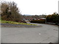
There are currently over 7.5m images from over14,400 individuals and you can help contribute to the project by visiting https://www.geograph.org.uk
Image Map
Images are licensed for reuse under creativecommons.org/licenses/by-sa/2.0
Notes
- Clicking on the map will re-center to the selected point.
- The higher the marker number, the further away the image location is from the centre of the postcode.
Image Listing (123 Images Found)
Images are licensed for reuse under creativecommons.org/licenses/by-sa/2.0
Image
Details
Distance
1
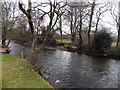
Ogmore River upstream from Riverside, Aberkenfig
A view from the residential street Riverside on the west bank of the Ogmore.
Image: © Jaggery
Taken: 27 Mar 2013
0.01 miles
2
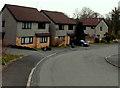
Riverside houses, Aberkenfig
The street is named Riverside, located on the west bank of the Ogmore River.
Image: © Jaggery
Taken: 27 Mar 2013
0.03 miles
3
Riverside houses, Aberkenfig
Houses on the west side of Riverside, a residential street on the west bank of the Ogmore River.
Image: © Jaggery
Taken: 27 Mar 2013
0.04 miles
4
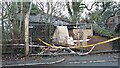
Aberkenfig
Aberkenfig, Bridgend Road, the recently collapsed building, was formerly famous for its sign on the building, the News of the World, which was also a former stables
Image: © Colin Prosser
Taken: 1 Jan 2022
0.04 miles
5
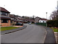
Riverside bend, Aberkenfig
Viewed from the corner of Bridgend Road.
Riverside is a residential street on the west bank of the Ogmore River.
Image: © Jaggery
Taken: 27 Mar 2013
0.05 miles
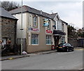
6

Bridgend Road houses at the southern edge of Aberkenfig
Viewed from the corner of the residential street Riverside.
Image: © Jaggery
Taken: 27 Mar 2013
0.07 miles
7
Swan Inn, Aberkenfig
Located at 128 Bridgend Road.
Image: © Jaggery
Taken: 27 Mar 2013
0.07 miles
8
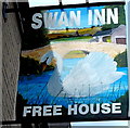
Swan Inn name sign, Aberkenfig
Attached to a wall here. http://www.geograph.org.uk/photo/3395647
Image: © Jaggery
Taken: 27 Mar 2013
0.07 miles
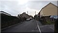
9

Northern end of Penyfai Road, Aberkenfig
A few metres behind the camera, Penyfai Road diverges from Bridgend Road. This view is alongside a small car park on the right. The School sign is for St Robert's RC primary school. http://www.geograph.org.uk/photo/3395451
Image: © Jaggery
Taken: 27 Mar 2013
0.07 miles
10
Aberkenfig
Aberkenfig, Penyfai Road, on the right is the entrance to The Woodlands, formerly known by locals as The Moulders
Image: © Colin Prosser
Taken: 1 Jan 2022
0.07 miles