IMAGES TAKEN NEAR TO
Aberkenfig, BRIDGEND, CF32 9AT
Introduction
This page details the photographs taken nearby to CF32 9AT by members of the Geograph project.
The Geograph project started in 2005 with the aim of publishing, organising and preserving representative images for every square kilometre of Great Britain, Ireland and the Isle of Man.

There are currently over 7.5m images from over14,400 individuals and you can help contribute to the project by visiting https://www.geograph.org.uk
Image Map
Images are licensed for reuse under creativecommons.org/licenses/by-sa/2.0
Notes
- Clicking on the map will re-center to the selected point.
- The higher the marker number, the further away the image location is from the centre of the postcode.
Image Listing (130 Images Found)
Images are licensed for reuse under creativecommons.org/licenses/by-sa/2.0
Image
Details
Distance
1
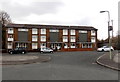
Dan-y-coed flats, Aberkenfig
The flats are at the western end of Dunraven Street.
Image: © Jaggery
Taken: 27 Mar 2013
0.00 miles
2
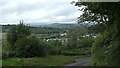
Aberkenfig Tondu
Aberkenfig Tondu, view from Alma Road by Penlan farm, across woodlands to Aberkenfig and Tondu, Wesleyan church and Chapel can be seen in distance, previous shot https://www.geograph.org.uk/photo/6998811 was at long zoom range from same spot.
Image: © Colin Prosser
Taken: 4 Jul 2021
0.01 miles
3
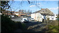
Aberkenfig
Aberkenfig, the old road from Cefn Cribbwr, which went into Dunraven Street, now reduced to a footpath, since the new bypass along Park Road has blocked off the old road.
Image: © Colin Prosser
Taken: 6 Apr 2015
0.02 miles
4
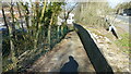
Aberkenfig
Aberkenfig, formerly the road from Cefn Cribbwr into Dunraven Street, now reduced to a footpath, since new bypass at Park Road
Image: © Colin Prosser
Taken: 6 Apr 2015
0.02 miles
5
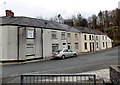
Houses at the far end of Dunraven Street, Aberkenfig
Viewed from the edge of the path http://www.geograph.org.uk/photo/3385937 from Church Street.
Image: © Jaggery
Taken: 27 Mar 2013
0.02 miles
6
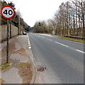
Park Road bus stops, Aberkenfig
The bus stops, one with a shelter, one without, are located alongside the B4281 Park Road.
Image: © Jaggery
Taken: 27 Mar 2013
0.03 miles
7
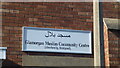
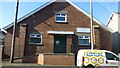
Aberkenfig
Aberkenfig, Dunraven Street, formerly St Roberts Hall, now a Muslim Community Centre
Image: © Colin Prosser
Taken: 6 Apr 2015
0.04 miles
8
Western section of Church Street, Aberkenfig
A view west along Church Street.
Out of shot ahead, Church Street bends to the left and ends http://www.geograph.org.uk/photo/3385937 at the edge of Dunraven Street.
Image: © Jaggery
Taken: 27 Mar 2013
0.05 miles
9
Aberkenfig
Aberkenfig, Dunraven Street, formerly St Roberts Hall, now a Muslim Community Centre
Image: © Colin Prosser
Taken: 6 Apr 2015
0.05 miles
10
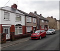
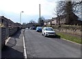
Semi-detached houses in Dunraven Street, Aberkenfig
Located near the western end of Dunraven Street, which ends at the edge of a stream, Nant Cynffig.
Image: © Jaggery
Taken: 27 Mar 2013
0.05 miles