IMAGES TAKEN NEAR TO
Dunraven Street, BRIDGEND, CF32 9AS
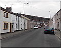
Introduction
This page details the photographs taken nearby to Dunraven Street, CF32 9AS by members of the Geograph project.
The Geograph project started in 2005 with the aim of publishing, organising and preserving representative images for every square kilometre of Great Britain, Ireland and the Isle of Man.

There are currently over 7.5m images from over14,400 individuals and you can help contribute to the project by visiting https://www.geograph.org.uk
Image Map
Images are licensed for reuse under creativecommons.org/licenses/by-sa/2.0
Notes
- Clicking on the map will re-center to the selected point.
- The higher the marker number, the further away the image location is from the centre of the postcode.
Image Listing (161 Images Found)
Images are licensed for reuse under creativecommons.org/licenses/by-sa/2.0
Image
Details
Distance
1
Aberkenfig
Aberkenfig, view along Dunraven Street
Image: © Colin Prosser
Taken: 6 Apr 2015
0.01 miles
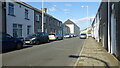
2
Dunraven Street, Aberkenfig
A view west from near the corner of Bridgend Road.
Image: © Jaggery
Taken: 27 Mar 2013
0.02 miles
3
A row of houses in Dunraven Street, Aberkenfig
Houses on the south side of the street viewed looking towards Bridgend Road.
Image: © Jaggery
Taken: 27 Mar 2013
0.02 miles
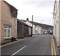
4
Glamorgan Muslim Community Centre, Aberkenfig
Located in the former St Roberts Hall, Dunraven Street.
Image: © Jaggery
Taken: 27 Mar 2013
0.03 miles
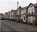
5
Housing variety on the south side of Dunraven Street, Aberkenfig
In the distance is this http://www.geograph.org.uk/photo/3385565 row of houses, and some semi-detached houses. http://www.geograph.org.uk/photo/3385579
Image: © Jaggery
Taken: 27 Mar 2013
0.03 miles
6
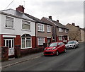
Semi-detached houses in Dunraven Street, Aberkenfig
Located near the western end of Dunraven Street, which ends at the edge of a stream, Nant Cynffig.
Image: © Jaggery
Taken: 27 Mar 2013
0.04 miles
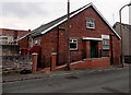
7
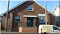
Aberkenfig
Aberkenfig, Dunraven Street, formerly St Roberts Hall, now a Muslim Community Centre
Image: © Colin Prosser
Taken: 6 Apr 2015
0.04 miles
8
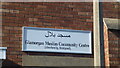
Aberkenfig
Aberkenfig, Dunraven Street, formerly St Roberts Hall, now a Muslim Community Centre
Image: © Colin Prosser
Taken: 6 Apr 2015
0.04 miles
9
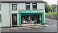
Bridgend Road Aberkenfig
Corner Bridgend Road, Church Street Aberkenfig, florist shop
Image: © Colin Prosser
Taken: 9 May 2023
0.06 miles
10
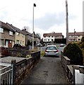
SW end of Church Street, Aberkenfig
For most of its length, Church Street is parallel with the north side of Dunraven Street.
Its SW end bends towards Dunraven Street, with the connecting path between the streets seen here.
Image: © Jaggery
Taken: 27 Mar 2013
0.06 miles