IMAGES TAKEN NEAR TO
Bettws, BRIDGEND, CF32 8UH
Introduction
This page details the photographs taken nearby to CF32 8UH by members of the Geograph project.
The Geograph project started in 2005 with the aim of publishing, organising and preserving representative images for every square kilometre of Great Britain, Ireland and the Isle of Man.

There are currently over 7.5m images from over14,400 individuals and you can help contribute to the project by visiting https://www.geograph.org.uk
Image Map
Images are licensed for reuse under creativecommons.org/licenses/by-sa/2.0
Notes
- Clicking on the map will re-center to the selected point.
- The higher the marker number, the further away the image location is from the centre of the postcode.
Image Listing (6 Images Found)
Images are licensed for reuse under creativecommons.org/licenses/by-sa/2.0
Image
Details
Distance
3
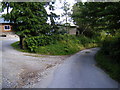
Road junction outside Bettws
A railway line used to cross at this junction, (heading east - west) but has been dismantled some time ago.
Image: © Roger
Taken: 31 Aug 2008
0.07 miles
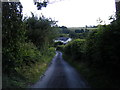
4
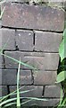
Ordnance Survey Cut Mark
This OS cut mark can be found on the east face of bridge. It marks a point 132.783m above mean sea level.
Image: © Adrian Dust
Taken: 18 Jun 2016
0.08 miles
5
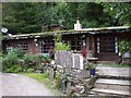
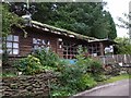
Ty Coed, Moel Giliau
According to the present owner, the log cabin was built without planning permission by a Ukrainian. The turf covered roof helped to hide it from aerial surveys
Image: © John Lord
Taken: 29 Aug 2008
0.08 miles