IMAGES TAKEN NEAR TO
Bettws, BRIDGEND, CF32 8UD
Introduction
This page details the photographs taken nearby to CF32 8UD by members of the Geograph project.
The Geograph project started in 2005 with the aim of publishing, organising and preserving representative images for every square kilometre of Great Britain, Ireland and the Isle of Man.

There are currently over 7.5m images from over14,400 individuals and you can help contribute to the project by visiting https://www.geograph.org.uk
Image Map
Images are licensed for reuse under creativecommons.org/licenses/by-sa/2.0
Notes
- Clicking on the map will re-center to the selected point.
- The higher the marker number, the further away the image location is from the centre of the postcode.
Image Listing (7 Images Found)
Images are licensed for reuse under creativecommons.org/licenses/by-sa/2.0
Image
Details
Distance
1
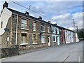
Glannant Row
Terraced houses in the village of Shwt.
Image: © Alan Hughes
Taken: 27 Feb 2023
0.06 miles
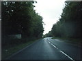
2
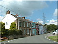
Shwt Cottages
In the village of Shwt at the western edge of this square
Image: © Chris Shaw
Taken: Unknown
0.09 miles
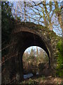
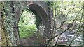
4
Derelict railway bridge
Derelict railway bridge near Shwt near Coytrahen alongside river Llynfi
Image: © Colin Prosser
Taken: 15 Sep 2021
0.21 miles
5
Derelict railway bridge
Derelict railway bridge near Shwt Coytrahen alongside River Llynfi
Image: © Colin Prosser
Taken: 15 Sep 2021
0.22 miles
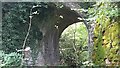
7
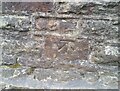
Ordnance Survey Cut Mark
This OS cut mark can be found on the east parapet of the bridge. It marks a point 64.520m above mean sea level.
Image: © Adrian Dust
Taken: 7 Mar 2021
0.23 miles