IMAGES TAKEN NEAR TO
Bettws, BRIDGEND, CF32 8TZ
Introduction
This page details the photographs taken nearby to CF32 8TZ by members of the Geograph project.
The Geograph project started in 2005 with the aim of publishing, organising and preserving representative images for every square kilometre of Great Britain, Ireland and the Isle of Man.

There are currently over 7.5m images from over14,400 individuals and you can help contribute to the project by visiting https://www.geograph.org.uk
Image Map
Images are licensed for reuse under creativecommons.org/licenses/by-sa/2.0
Notes
- Clicking on the map will re-center to the selected point.
- The higher the marker number, the further away the image location is from the centre of the postcode.
Image Listing (4 Images Found)
Images are licensed for reuse under creativecommons.org/licenses/by-sa/2.0
Image
Details
Distance
1
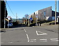
Unnamed road from Bettws towards Shwt
On the west side of Bettws Road.
Image: © Jaggery
Taken: 24 Nov 2017
0.24 miles
2
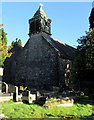
Bellcote and weathervane, St David's Church, Bettws
Part of this https://www.geograph.org.uk/photo/5641881 Grade I listed church. Cadw records that this exceptional square bellcote at the west end of the nave stands on a shallow stone base supported on the west side by corbels, with square headed openings north, east and south and stone louvres on the west side. Gargoyles are on each upper corner and a corbelled base to a pyramidal roof, surmounted by a fish weathervane. https://www.geograph.org.uk/photo/5641910 The bellcote reputedly houses two bells of 1891.
Image: © Jaggery
Taken: 24 Nov 2017
0.24 miles
3
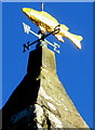
Fish weathervane on the bellcote, St David's Church, Bettws
On top of this https://www.geograph.org.uk/photo/5641908 bellcote.
Image: © Jaggery
Taken: 24 Nov 2017
0.24 miles
4
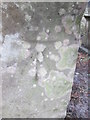
Ordnance Survey Cut Mark
This OS cut mark can be found on the porch of St David's Church. It marks a point 137.669m above mean sea level.
Image: © Adrian Dust
Taken: 9 Mar 2016
0.25 miles