IMAGES TAKEN NEAR TO
Dan-yr-Eglwys, BRIDGEND, CF32 8TJ
Introduction
This page details the photographs taken nearby to Dan-yr-Eglwys, CF32 8TJ by members of the Geograph project.
The Geograph project started in 2005 with the aim of publishing, organising and preserving representative images for every square kilometre of Great Britain, Ireland and the Isle of Man.

There are currently over 7.5m images from over14,400 individuals and you can help contribute to the project by visiting https://www.geograph.org.uk
Image Map
Images are licensed for reuse under creativecommons.org/licenses/by-sa/2.0
Notes
- Clicking on the map will re-center to the selected point.
- The higher the marker number, the further away the image location is from the centre of the postcode.
Image Listing (52 Images Found)
Images are licensed for reuse under creativecommons.org/licenses/by-sa/2.0
Image
Details
Distance
2
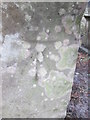
Ordnance Survey Cut Mark
This OS cut mark can be found on the porch of St David's Church. It marks a point 137.669m above mean sea level.
Image: © Adrian Dust
Taken: 9 Mar 2016
0.05 miles
3
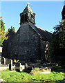
Bellcote and weathervane, St David's Church, Bettws
Part of this https://www.geograph.org.uk/photo/5641881 Grade I listed church. Cadw records that this exceptional square bellcote at the west end of the nave stands on a shallow stone base supported on the west side by corbels, with square headed openings north, east and south and stone louvres on the west side. Gargoyles are on each upper corner and a corbelled base to a pyramidal roof, surmounted by a fish weathervane. https://www.geograph.org.uk/photo/5641910 The bellcote reputedly houses two bells of 1891.
Image: © Jaggery
Taken: 24 Nov 2017
0.05 miles
4
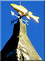
Fish weathervane on the bellcote, St David's Church, Bettws
On top of this https://www.geograph.org.uk/photo/5641908 bellcote.
Image: © Jaggery
Taken: 24 Nov 2017
0.05 miles
5
Information board at the entrance to St David's Church, Bettws
Facing Bettws Road on the left here. https://www.geograph.org.uk/photo/5641890
Image: © Jaggery
Taken: 24 Nov 2017
0.05 miles
6
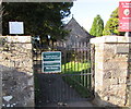
Commonwealth War Graves notice, Bettws
Facing Bettws Road at the entrance to St David's churchyard, the notice states
At this location there are Commonwealth War Graves.
The notice above it is in Welsh.
Image: © Jaggery
Taken: 24 Nov 2017
0.05 miles
7
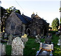
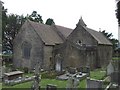
Grade I listed Church of St David, Bettws
Part of the Church in Wales Diocese of Llandaff. Cadw records that the church may have an early medieval origin, the dedication to St David being later, and the original churchyard boundary roughly circular. This building is believed to date from the 12th century and is probably identifiable in a charter of the Bishop of Llandaff who died in 1183. Substantially remodelled in the 15th and 16th centuries. Until 1885 a curacy of Newcastle, together with Laleston and Tythegston with revenues paid first to Tewkesbury Abbey and from the 13th century to Margam Abbey. Bettws was within the boundaries of Tir Iarll held by the Lords of Glamorgan and was a literary centre in the later Middle Ages, with two named 15th century poets, Dafydd Fychan and Llewelyn Goch y Dant, living in the parish. The church was restored and extended by the addition of the north aisle in 1893, the work paid for by Miss Olive Talbot of Margam. The building was Grade I listed in 1997.
Image: © Jaggery
Taken: 24 Nov 2017
0.05 miles
8
Entrance to Betws Primary School, Bettws
From Bettws Road. The English name of the school uses the Welsh spelling Betws whereas Bettws is more often used in English, such as here http://www.geograph.org.uk/photo/5609491 at a village boundary.
Image: © Jaggery
Taken: 24 Nov 2017
0.06 miles
9

Two speed bumps, Bettws Road, Bettws
A primary school entrance http://www.geograph.org.uk/photo/5610499 is 40 metres behind the camera.
Image: © Jaggery
Taken: 24 Nov 2017
0.06 miles
10
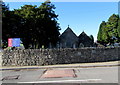
St David's churchyard eastern perimeter wall, Bettws
Across Bettws Road towards the Grade I listed Church of St David. https://www.geograph.org.uk/photo/5641881
Image: © Jaggery
Taken: 24 Nov 2017
0.06 miles