IMAGES TAKEN NEAR TO
Heol Y Felin, BRIDGEND, CF32 8TE
Introduction
This page details the photographs taken nearby to Heol Y Felin, CF32 8TE by members of the Geograph project.
The Geograph project started in 2005 with the aim of publishing, organising and preserving representative images for every square kilometre of Great Britain, Ireland and the Isle of Man.

There are currently over 7.5m images from over14,400 individuals and you can help contribute to the project by visiting https://www.geograph.org.uk
Image Map
Images are licensed for reuse under creativecommons.org/licenses/by-sa/2.0
Notes
- Clicking on the map will re-center to the selected point.
- The higher the marker number, the further away the image location is from the centre of the postcode.
Image Listing (36 Images Found)
Images are licensed for reuse under creativecommons.org/licenses/by-sa/2.0
Image
Details
Distance
1
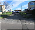
Heol y Felin, Bettws
Ascending from the east side of Bettws Road.
Image: © Jaggery
Taken: 24 Nov 2017
0.02 miles
2
Small Christmas tree in a pot on a Bettws Road lamppost, Bettws
Viewed on November 24th 2017.
Image: © Jaggery
Taken: 24 Nov 2017
0.08 miles
3
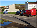
Royal Mail van, Bettws Road, Bettws
The identifier BE71 on the red van shows that it is based at Bridgend Delivery Office.
Image: © Jaggery
Taken: 24 Nov 2017
0.08 miles
4
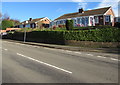
Bungalows above Bettws Road, Bettws
Originally, bungalow was used in English for a lightly-built house, with a veranda and one storey.
In current UK usage it is a convenient word for any one-storey dwelling.
Image: © Jaggery
Taken: 24 Nov 2017
0.08 miles
6
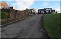
Tudor Drive, Bettws
Ascending from the east side of Bettws Road, Tudor Drive leads to Tyn y Bettws Close.
Image: © Jaggery
Taken: 24 Nov 2017
0.09 miles
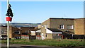
7
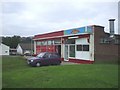
Derelict former shop, Bettws
In November 2017 the name Eastside Stores remains on the derelict building on the east side of Bettws Road.
Image: © Jaggery
Taken: 24 Nov 2017
0.10 miles
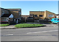
8
Trem-y-mor, Bettws
Residential care home on the west side of Bettws Road.
Image: © Jaggery
Taken: 24 Nov 2017
0.10 miles
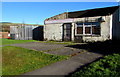
9
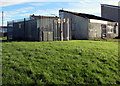
Bettws West electricity substation, Bettws
The Western Power Distribution electricity substation is set back from Bettws Road next to the derelict former Eastside Stores. http://www.geograph.org.uk/photo/5609131 The substation identifier is Bettws West S/S 563091.
Image: © Jaggery
Taken: 24 Nov 2017
0.10 miles
10
Woodlands Close, Bettws
On the west side of Bettws Road.
Image: © Jaggery
Taken: 24 Nov 2017
0.10 miles