IMAGES TAKEN NEAR TO
Fountain Terrace, BRIDGEND, CF32 8TD
Introduction
This page details the photographs taken nearby to Fountain Terrace, CF32 8TD by members of the Geograph project.
The Geograph project started in 2005 with the aim of publishing, organising and preserving representative images for every square kilometre of Great Britain, Ireland and the Isle of Man.

There are currently over 7.5m images from over14,400 individuals and you can help contribute to the project by visiting https://www.geograph.org.uk
Image Map
Images are licensed for reuse under creativecommons.org/licenses/by-sa/2.0
Notes
- Clicking on the map will re-center to the selected point.
- The higher the marker number, the further away the image location is from the centre of the postcode.
Image Listing (55 Images Found)
Images are licensed for reuse under creativecommons.org/licenses/by-sa/2.0
Image
Details
Distance
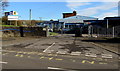
1

Scott building site, Bettws
Andrew Scott Ltd building site viewed across Bettws Road on November 24th 2017.
Image: © Jaggery
Taken: 24 Nov 2017
0.02 miles
2
Entrance to Betws Primary School, Bettws
From Bettws Road. The English name of the school uses the Welsh spelling Betws whereas Bettws is more often used in English, such as here http://www.geograph.org.uk/photo/5609491 at a village boundary.
Image: © Jaggery
Taken: 24 Nov 2017
0.03 miles
5
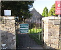
Commonwealth War Graves notice, Bettws
Facing Bettws Road at the entrance to St David's churchyard, the notice states
At this location there are Commonwealth War Graves.
The notice above it is in Welsh.
Image: © Jaggery
Taken: 24 Nov 2017
0.05 miles
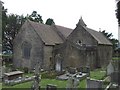
6
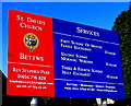
Information board at the entrance to St David's Church, Bettws
Facing Bettws Road on the left here. https://www.geograph.org.uk/photo/5641890
Image: © Jaggery
Taken: 24 Nov 2017
0.05 miles
7
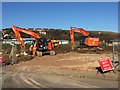
Heavy MachInery
Heavy machinery preparing ground for development at Bettws.
Image: © Alan Hughes
Taken: 20 Jan 2017
0.05 miles
8

Two speed bumps, Bettws Road, Bettws
A primary school entrance http://www.geograph.org.uk/photo/5610499 is 40 metres behind the camera.
Image: © Jaggery
Taken: 24 Nov 2017
0.05 miles
9
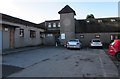
Bettws Life Centre, Bettws
Facilities include a cafe, bar, rentable office spaces, main hall, crèche, library, computer suite & training room.
Image: © Jaggery
Taken: 24 Nov 2017
0.05 miles
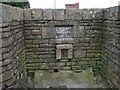
10
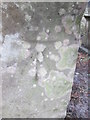
Ordnance Survey Cut Mark
This OS cut mark can be found on the porch of St David's Church. It marks a point 137.669m above mean sea level.
Image: © Adrian Dust
Taken: 9 Mar 2016
0.06 miles