IMAGES TAKEN NEAR TO
Heol Llwynffynon, BRIDGEND, CF32 8PR
Introduction
This page details the photographs taken nearby to Heol Llwynffynon, CF32 8PR by members of the Geograph project.
The Geograph project started in 2005 with the aim of publishing, organising and preserving representative images for every square kilometre of Great Britain, Ireland and the Isle of Man.

There are currently over 7.5m images from over14,400 individuals and you can help contribute to the project by visiting https://www.geograph.org.uk
Image Map
Images are licensed for reuse under creativecommons.org/licenses/by-sa/2.0
Notes
- Clicking on the map will re-center to the selected point.
- The higher the marker number, the further away the image location is from the centre of the postcode.
Image Listing (5 Images Found)
Images are licensed for reuse under creativecommons.org/licenses/by-sa/2.0
Image
Details
Distance
1

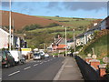
Road past the school in Llangeinor
In the Garw valley.
Image: © Andrew Hill
Taken: 21 Oct 2008
0.11 miles
2
Valley road north through Llangeinor
In the Garw Valley.
Image: © Andrew Hill
Taken: 21 Oct 2008
0.14 miles
3

Garw valley at Llangeinor
Looking north towards the upper section of the valley.
Image: © Andrew Hill
Taken: 21 Oct 2008
0.14 miles
4

Cycle path at old railway bridge over the Afon Garw by Llangeinor
The path followed by Route 884 of the National Cycle Network – a.k.a. The Garw Valley Community Route – crosses a bridge originally built to carry a railway line between Tondu and Blaengarw over the river.
That line is long disused. It is hoped though that trains will again run along the course of much of the old line on the Garw Valley Railway (see http://garw-railway.co.uk/ ). Track remains in place on a good part of the proposed route. The photograph though was taken by one of the stretches where the track has been dismantled.
Image: © eswales
Taken: Unknown
0.15 miles
5
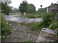
Road crossing disused railway
The railway line is now considerably overgrown in parts
Image: © Roger
Taken: 31 Aug 2008
0.24 miles