IMAGES TAKEN NEAR TO
Bettws Road, BRIDGEND, CF32 8PH
Introduction
This page details the photographs taken nearby to Bettws Road, CF32 8PH by members of the Geograph project.
The Geograph project started in 2005 with the aim of publishing, organising and preserving representative images for every square kilometre of Great Britain, Ireland and the Isle of Man.

There are currently over 7.5m images from over14,400 individuals and you can help contribute to the project by visiting https://www.geograph.org.uk
Image Map
Images are licensed for reuse under creativecommons.org/licenses/by-sa/2.0
Notes
- Clicking on the map will re-center to the selected point.
- The higher the marker number, the further away the image location is from the centre of the postcode.
Image Listing (10 Images Found)
Images are licensed for reuse under creativecommons.org/licenses/by-sa/2.0
Image
Details
Distance
1
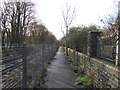
View south from the site of Llangeinor station
At the site of the old station. The cycle path is well surfaced, although a bit narrow at this point, and runs between Bryngarw Country Park and Blaengarw. The railway track to the left is disused but still mostly in place as the line may be reopened in the future between Pontycymer and Tondu (see http://www.garw-railway.co.uk/ for latest details).
Image: © John Light
Taken: 13 Jan 2012
0.08 miles
2
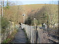
Cycle path running alongside the disused railway
Near the old level crossing at Llangeinor. The cycle path is well surfaced and runs between Bryngarw Country Park and Blaengarw. The railway track is disused but still mostly in place as the line may be reopened in the future between Pontycymer and Tondu (see http://www.garw-railway.co.uk/ for latest details).
Image: © John Light
Taken: 13 Jan 2012
0.09 miles
3

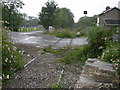
Level crossing rails in situ in Llangeinor
Image: © Colin Pyle
Taken: 15 Jul 2012
0.09 miles
4
Road crossing disused railway
The railway line is now considerably overgrown in parts
Image: © Roger
Taken: 31 Aug 2008
0.10 miles
5

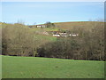
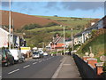
Garw valley at Llangeinor
Looking north towards the upper section of the valley.
Image: © Andrew Hill
Taken: 21 Oct 2008
0.16 miles
6
Field west of Llangeinor
Taken from the public footpath - which soon heads downhill through the trees, then crossing a stream. In the distance are some houses on the outskirts of Llangeinor, and Cefngelli farm.
Image: © John Light
Taken: 13 Jan 2012
0.18 miles
7
Valley road north through Llangeinor
In the Garw Valley.
Image: © Andrew Hill
Taken: 21 Oct 2008
0.22 miles
8

Llangeinor near the turn for Bettws
In the Garw Valley.
Image: © Andrew Hill
Taken: 21 Oct 2008
0.23 miles
9
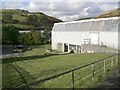
Llangeinor
Facing North Westerly, this picture shows the Richard Price Centre which is an Adult Learning Centre.
Image: © Kev Griffin
Taken: 16 Nov 2004
0.24 miles
10

Road past the school in Llangeinor
In the Garw valley.
Image: © Andrew Hill
Taken: 21 Oct 2008
0.24 miles