IMAGES TAKEN NEAR TO
School Terrace, BRIDGEND, CF32 8NF
Introduction
This page details the photographs taken nearby to School Terrace, CF32 8NF by members of the Geograph project.
The Geograph project started in 2005 with the aim of publishing, organising and preserving representative images for every square kilometre of Great Britain, Ireland and the Isle of Man.

There are currently over 7.5m images from over14,400 individuals and you can help contribute to the project by visiting https://www.geograph.org.uk
Image Map
Images are licensed for reuse under creativecommons.org/licenses/by-sa/2.0
Notes
- Clicking on the map will re-center to the selected point.
- The higher the marker number, the further away the image location is from the centre of the postcode.
Image Listing (57 Images Found)
Images are licensed for reuse under creativecommons.org/licenses/by-sa/2.0
Image
Details
Distance
1
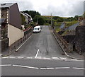
School Terrace, Blaengarw
School Terrace climbs steeply await from the A4064 King Edward Street towards Tymeinwr Avenue.
Image: © Jaggery
Taken: 15 Aug 2014
0.02 miles
2
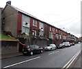
King Edward Street houses, Blaengarw
A long row of houses set above road level.
Image: © Jaggery
Taken: 1 Sep 2014
0.03 miles
3
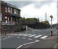
Zebra crossing in Blaengarw
Looking across the A4064 King Edward Street towards the corner of School Terrace. http://www.geograph.org.uk/photo/4120181
Although Belisha beacons had marked pedestrian crossings in the UK from 1934, it was not until 1951 that the now familiar black and white stripes stretching across the width of the road were officially introduced. Previously, there were only metal studs across the road surface.
Image: © Jaggery
Taken: 15 Aug 2014
0.03 miles
4
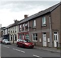
74A and 74B King Edward Street, Blaengarw
The corner house, formerly 74 King Edward Street, has been divided
into two properties, each with its own front door, and meter box on the wall.
Image: © Jaggery
Taken: 15 Aug 2014
0.04 miles
5
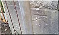
Ordnance Survey Cut Mark
This OS cut mark can be found on the gatepost of the former school. It marks a point 180.935m above mean sea level.
Image: © Adrian Dust
Taken: 29 May 2017
0.05 miles
6
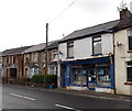
Abandoned shop in Blaengarw
Stock on shelves can be seen through the window of the dark blue shop frontage in King Edward Street.
Image: © Jaggery
Taken: 1 Sep 2014
0.05 miles
7
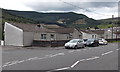
Darren Bungalows, Blaengarw
On the west side of the A4064 King Edward Street.
Image: © Jaggery
Taken: 15 Aug 2014
0.05 miles
8
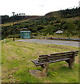
Bench and electricity substation in Blaengarw
Located on the west side of King Edward Street. The identifier on the Western Power Distribution electricity substation is KING EDWARD ST S/S 563632.
Image: © Jaggery
Taken: 15 Aug 2014
0.06 miles
9
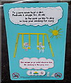
No smoking in this play area notice, Blaengarw
On the entrance gate from King Edward Street to this http://www.geograph.org.uk/photo/4147316 play area.
"In this park we like to play
so keep your smoking far away".
Image: © Jaggery
Taken: 1 Sep 2014
0.08 miles
10
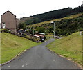
Road into the Garw valley, Blaengarw
The road descends from the A4064 King Edward Street towards a river, Afon Garw.
Image: © Jaggery
Taken: 15 Aug 2014
0.08 miles