IMAGES TAKEN NEAR TO
The Avenue, BRIDGEND, CF32 8LY
Introduction
This page details the photographs taken nearby to The Avenue, CF32 8LY by members of the Geograph project.
The Geograph project started in 2005 with the aim of publishing, organising and preserving representative images for every square kilometre of Great Britain, Ireland and the Isle of Man.

There are currently over 7.5m images from over14,400 individuals and you can help contribute to the project by visiting https://www.geograph.org.uk
Image Map
Images are licensed for reuse under creativecommons.org/licenses/by-sa/2.0
Notes
- Clicking on the map will re-center to the selected point.
- The higher the marker number, the further away the image location is from the centre of the postcode.
Image Listing (63 Images Found)
Images are licensed for reuse under creativecommons.org/licenses/by-sa/2.0
Image
Details
Distance
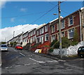
1
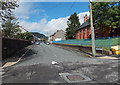
The Avenue, Pontycymer
Viewed from St David Street. St David's Church http://www.geograph.org.uk/photo/4148555 is on the right.
Image: © Jaggery
Taken: 1 Sep 2014
0.05 miles
2
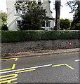
Victoria Street postbox in a wall, Pontycymer
The King George VI postbox http://www.geograph.org.uk/photo/4148519 is on the east side of the road.
Image: © Jaggery
Taken: 1 Sep 2014
0.05 miles
3
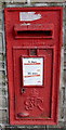
King George VI postbox in a wall, Pontycymer
Located here. http://www.geograph.org.uk/photo/4148512 Notices in Welsh and English give details
of forthcoming changes in the last collection time each day.
Image: © Jaggery
Taken: 1 Sep 2014
0.05 miles
4
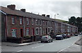
Long row of houses in Pontycymer
Extending for c135 metres (about 440 ft) along the east side of the A4064 Victoria Street.
Image: © Jaggery
Taken: 1 Sep 2014
0.05 miles
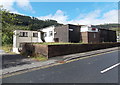
5
Pontycymer Police Station
Viewed across the A4064 Victoria Street. Pontycymer War Memorial http://www.geograph.org.uk/photo/4148435 is on the right.
Image: © Jaggery
Taken: 1 Sep 2014
0.05 miles
6
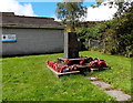
Pontycymer War Memorial
On the west side of Victoria Street, in front of the police station. http://www.geograph.org.uk/photo/4148428
Image: © Jaggery
Taken: 1 Sep 2014
0.05 miles
7
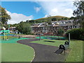
Victoria Street recreation area, Pontycymer
Real grass at the right edge of the view. Two shades of artificial grass elsewhere.
Image: © Jaggery
Taken: 1 Sep 2014
0.05 miles
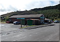
8
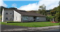
Blaengarw RFC clubhouse, Pontycymer
Blaengarw rugby union club's clubhouse is in Victoria Street in Pontycymer,
the next village south from Blaengarw in the Garw Valley.
Image: © Jaggery
Taken: 1 Sep 2014
0.06 miles
9
The Co-operative Pharmacy in Pontycymer
Set back 30 metres from the west side of Victoria Street.
Image: © Jaggery
Taken: 1 Sep 2014
0.06 miles
10
Upper Adare Street, Pontycymer
Looking north from St David Street.
Image: © Jaggery
Taken: 1 Sep 2014
0.07 miles