IMAGES TAKEN NEAR TO
Lower Adare Street, BRIDGEND, CF32 8LW
Introduction
This page details the photographs taken nearby to Lower Adare Street, CF32 8LW by members of the Geograph project.
The Geograph project started in 2005 with the aim of publishing, organising and preserving representative images for every square kilometre of Great Britain, Ireland and the Isle of Man.

There are currently over 7.5m images from over14,400 individuals and you can help contribute to the project by visiting https://www.geograph.org.uk
Image Map
Images are licensed for reuse under creativecommons.org/licenses/by-sa/2.0
Notes
- Clicking on the map will re-center to the selected point.
- The higher the marker number, the further away the image location is from the centre of the postcode.
Image Listing (91 Images Found)
Images are licensed for reuse under creativecommons.org/licenses/by-sa/2.0
Image
Details
Distance
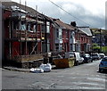
1
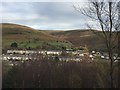
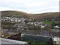
Pontycymer, Fforch-Wen and Mynydd Llangeinwyr
View across the Garw valley towards Pontycymer, with the valley of Fforch-Wen and Mynydd Llangeinwyr in the background.
Image: © Alan Hughes
Taken: 13 Nov 2017
0.04 miles
2
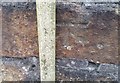
Ordnance Survey Cut Mark
This OS cut mark can be found on the wall SE side of the cross roads. It marks a point 188.619m above mean sea level.
Image: © Adrian Dust
Taken: 29 May 2017
0.05 miles
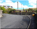
3
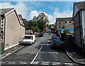
St David Street, Pontycymer
St David Street climbs away from the A4064 Victoria Street.
Image: © Jaggery
Taken: 1 Sep 2014
0.05 miles
4
North along Hill View, Pontycymer
Looking north (more exactly NNW) from a bend in the road. http://www.geograph.org.uk/photo/4149926
Image: © Jaggery
Taken: 1 Sep 2014
0.05 miles
5
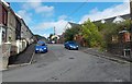
Hill View houses, Pontycymer
Houses on the east side of Hill View, viewed from the corner of St David Street.
Image: © Jaggery
Taken: 1 Sep 2014
0.05 miles
6
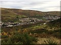
View of Pontycymer
View of Pontycymer from a footpath through the Garw Forest.
Image: © Alan Hughes
Taken: 13 Nov 2017
0.06 miles
7
Yellow grit box at a bend in Hill View, Pontycymer
The contents of the grit box are used to treat the road surface in icy or snowy weather.
Image: © Jaggery
Taken: 1 Sep 2014
0.07 miles
8
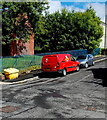
Royal Mail van in Pontycymer
The red van is parked in St David Street. The brick wall is the southern edge of St David's Church. http://www.geograph.org.uk/photo/4148555
Image: © Jaggery
Taken: 1 Sep 2014
0.07 miles
9
Pontycymer
View of Pontycymer from the footpath leading up into Garw Forest.
Image: © Alan Hughes
Taken: 13 Nov 2017
0.07 miles
10
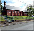
St David's Church, Pontycymer
This is The Avenue side of the Church in Wales church on the corner of St David Street.
The church is in the Parish of Llangeinor and the Garw Valley, Diocese of Llandaff.
Image: © Jaggery
Taken: 1 Sep 2014
0.07 miles