1
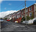
Upper Adare Street, Pontycymer
Looking north from St David Street.
Image: © Jaggery
Taken: 1 Sep 2014
0.01 miles
2
St David Street, Pontycymer
St David Street climbs away from the A4064 Victoria Street.
Image: © Jaggery
Taken: 1 Sep 2014
0.06 miles
3
Ordnance Survey Cut Mark
This OS cut mark can be found on the wall SE side of the cross roads. It marks a point 188.619m above mean sea level.
Image: © Adrian Dust
Taken: 29 May 2017
0.06 miles
4
The Avenue, Pontycymer
Viewed from St David Street. St David's Church http://www.geograph.org.uk/photo/4148555 is on the right.
Image: © Jaggery
Taken: 1 Sep 2014
0.06 miles
5
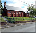
St David's Church, Pontycymer
This is The Avenue side of the Church in Wales church on the corner of St David Street.
The church is in the Parish of Llangeinor and the Garw Valley, Diocese of Llandaff.
Image: © Jaggery
Taken: 1 Sep 2014
0.06 miles
6
Pontycymer
View of Pontycymer from the footpath leading up into Garw Forest.
Image: © Alan Hughes
Taken: 13 Nov 2017
0.07 miles
7
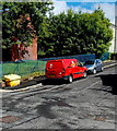
Royal Mail van in Pontycymer
The red van is parked in St David Street. The brick wall is the southern edge of St David's Church. http://www.geograph.org.uk/photo/4148555
Image: © Jaggery
Taken: 1 Sep 2014
0.07 miles
8
Recently-built house, St David Street, Pontycymer
At the start of September 2014, a FOR SALE sign is outside a house which did not exist at the June 2011 date of a Google Earth Street View, which shows a bare brick and stone building of a different shape here, with all its windows blocked up.
Image: © Jaggery
Taken: 1 Sep 2014
0.10 miles
9
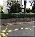
King George VI postbox in a wall, Pontycymer
Located here. http://www.geograph.org.uk/photo/4148512 Notices in Welsh and English give details
of forthcoming changes in the last collection time each day.
Image: © Jaggery
Taken: 1 Sep 2014
0.10 miles
10
Victoria Street postbox in a wall, Pontycymer
The King George VI postbox http://www.geograph.org.uk/photo/4148519 is on the east side of the road.
Image: © Jaggery
Taken: 1 Sep 2014
0.10 miles


