IMAGES TAKEN NEAR TO
Llangeinor, BRIDGEND, CF32 8HX
Introduction
This page details the photographs taken nearby to CF32 8HX by members of the Geograph project.
The Geograph project started in 2005 with the aim of publishing, organising and preserving representative images for every square kilometre of Great Britain, Ireland and the Isle of Man.

There are currently over 7.5m images from over14,400 individuals and you can help contribute to the project by visiting https://www.geograph.org.uk
Image Map
Images are licensed for reuse under creativecommons.org/licenses/by-sa/2.0
Notes
- Clicking on the map will re-center to the selected point.
- The higher the marker number, the further away the image location is from the centre of the postcode.
Image Listing (9 Images Found)
Images are licensed for reuse under creativecommons.org/licenses/by-sa/2.0
Image
Details
Distance
1
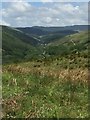
View from Bryn y Wrach
View along the Garw valley from Bryn y Wrach.
Image: © Alan Hughes
Taken: 18 May 2017
0.09 miles
2
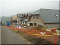
New homes - construction on edge of Llangeinor
These properties are being built just outside the village centre with commanding views over the valley
Image: © Roger
Taken: 31 Aug 2008
0.10 miles
3
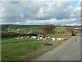
Flytipping near Llangeinor.
It is difficult for some of us to comprehend what leads some people to go to such lengths to dispose of their rubbish. This is a beautiful location with little habitation in the immediate vicinity yet someone has chosen to bring yesteryears toys here, perhaps in readiness for the not long off Christmas of this year!
Image: © Mick Lobb
Taken: 22 Oct 2008
0.16 miles
4
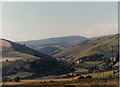
Park Road Llangeinor July 1989
A view off Park Road Llangeinor towards the Garw valley July 1989
Image: © Colin Prosser
Taken: Unknown
0.16 miles
5
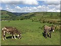
Donkeys and Foal at Bryn y Wrach
Donkeys and foal at Bryn y Wrach with the Garw valley in the distance.
Image: © Alan Hughes
Taken: 18 May 2017
0.18 miles

7
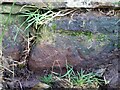
Ordnance Survey Cut Mark
This OS cut mark can be found on the wall SE of the cross roads. It marks a point 194.752m above mean sea level.
Image: © Adrian Dust
Taken: 27 Feb 2021
0.21 miles
8
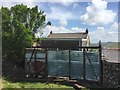
Bryn y Wrach Farm
Remains of a railway carriage used as a barrier at Bryn y Wrach.
Image: © Alan Hughes
Taken: 18 May 2017
0.24 miles
