IMAGES TAKEN NEAR TO
Alexandra Road, BRIDGEND, CF32 8HA
Introduction
This page details the photographs taken nearby to Alexandra Road, CF32 8HA by members of the Geograph project.
The Geograph project started in 2005 with the aim of publishing, organising and preserving representative images for every square kilometre of Great Britain, Ireland and the Isle of Man.

There are currently over 7.5m images from over14,400 individuals and you can help contribute to the project by visiting https://www.geograph.org.uk
Image Map
Images are licensed for reuse under creativecommons.org/licenses/by-sa/2.0
Notes
- Clicking on the map will re-center to the selected point.
- The higher the marker number, the further away the image location is from the centre of the postcode.
Image Listing (123 Images Found)
Images are licensed for reuse under creativecommons.org/licenses/by-sa/2.0
Image
Details
Distance
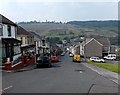
1

Steep ascent along Alexandra Road, Pontycymer
Looking east from the corner of Oxford Street.
Image: © Jaggery
Taken: 1 Sep 2014
0.01 miles
2

Modern houses in Alexandra Road, Pontycymer
Row of eight houses, 9A-9H Alexandra Road, viewed from the corner of Meadow Street.
Image: © Jaggery
Taken: 1 Sep 2014
0.01 miles
3

Pontycymmer Clinic in Pontycymer
Viewed across Alexandra Road. The bilingual name board shows the Welsh name of the village, Pontycymer and its English form Pontycymmer. In recent years, the spelling Pontycymer has become prevalent in English use.
The inscription shows the original usage of the building erected in 1939. M and CW Clinic was a Maternity and Child Welfare Clinic. Ogmore and Garw UDC was an Urban District Council formed in 1894. It ceased to exist on March 31st 1974, and was merged with the Urban Districts of Bridgend, Maesteg, Porthcawl (and Penybont Rural District) to form Ogwr (later Bridgend) Borough Council.
The area became part of Bridgend County Borough in 1996.
Image: © Jaggery
Taken: 1 Sep 2014
0.02 miles
4
Down Alexandra Road Pontycymer
Viewed from the edge of Gelliron Cemetery, Alexandra Road descends towards Oxford Street.
Image: © Jaggery
Taken: 6 Sep 2014
0.02 miles
5
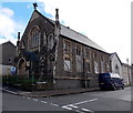
Derelict former church for sale, Pontycymer
In early September 2014, there was a FOR SALE sign outside this building on the corner of Alexandra Road and Meadow Street. When last used for worship, it was a United Reformed Church. It was built as an English Congregational Church in the first decade of the 20th century to replace the first church here, a zinc chapel. Grade II listed status (1997) has not prevented the building's dereliction.
Image: © Jaggery
Taken: 1 Sep 2014
0.02 miles
6
New Town, Pontycymer
Chinese takeaway & fish bar at 16 Oxford Street, opposite The Squirrel. http://www.geograph.org.uk/photo/4149340
Image: © Jaggery
Taken: 1 Sep 2014
0.03 miles
7
Oxford Street shops near the corner of Alexandra Road, Pontycymer
Looking towards The Squirrel. http://www.geograph.org.uk/photo/4149340 The only other business name in view is R&B Barbers, centre right.
Image: © Jaggery
Taken: 1 Sep 2014
0.03 miles
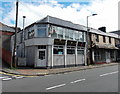
8
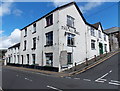
The Squirrel, Pontycymer
The large white building on the corner of Oxford Street and Alexandra Road is stated in various online sources to be a pub, but whether that is still so here in early September 2014 looks unlikely.
The Oxford Street side (on the left) appears to be (or to have been) in use as an unnamed shop.
Image: © Jaggery
Taken: 1 Sep 2014
0.03 miles
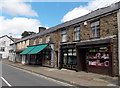
9
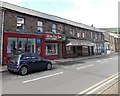
Blodau Cwm Garw in Pontycymer
Blodau Cwm Garw on the left is a florist and giftware shop at 21-25 Oxford Street.
Clive Morgan Roberts next door is a shoe shop.
Image: © Jaggery
Taken: 1 Sep 2014
0.03 miles
10
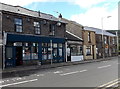
Unnamed cafe in Pontycymer
Viewed across Oxford Street near the Alexandra Road junction.
There is no name on the nameboard. Nieve's hair & beauty salon is on the right.
Image: © Jaggery
Taken: 1 Sep 2014
0.03 miles