IMAGES TAKEN NEAR TO
Chapel Street, BRIDGEND, CF32 8EG
Introduction
This page details the photographs taken nearby to Chapel Street, CF32 8EG by members of the Geograph project.
The Geograph project started in 2005 with the aim of publishing, organising and preserving representative images for every square kilometre of Great Britain, Ireland and the Isle of Man.

There are currently over 7.5m images from over14,400 individuals and you can help contribute to the project by visiting https://www.geograph.org.uk
Image Map
Images are licensed for reuse under creativecommons.org/licenses/by-sa/2.0
Notes
- Clicking on the map will re-center to the selected point.
- The higher the marker number, the further away the image location is from the centre of the postcode.
Image Listing (107 Images Found)
Images are licensed for reuse under creativecommons.org/licenses/by-sa/2.0
Image
Details
Distance
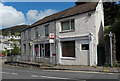
1
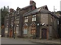
Royal Hotel, Pontycymer
I asked a passer-by about this building and she told me that it was The Royal Hotel, and that it had been built by her great-grandfather but had closed about ten years ago.
Cf Image
Image: © Alan Hughes
Taken: 13 Nov 2017
0.02 miles
2
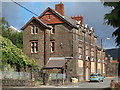
Royal Hotel Pontycymmer
Yet another pub that has closed in the recent past
Image: © John Finch
Taken: 30 Aug 2012
0.03 miles
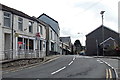
3
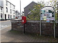
Community noticeboard and postbox in Pontycymer
On the west side of Oxford Street, opposite the post office. The postbox was installed when the large postbox in the post office wall was removed to make space for the installation of a cash dispenser. http://www.geograph.org.uk/photo/4150030
Image: © Jaggery
Taken: 1 Sep 2014
0.05 miles
4
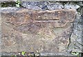
Ordnance Survey Cut Mark
This OS cut mark can be found on No5 Oxford Street. It marks a point 156.021m above mean sea level.
Image: © Adrian Dust
Taken: 29 May 2017
0.05 miles
5

Oxford Street opposite Alexandra Road, Pontycymer
Looking down from here. http://www.geograph.org.uk/photo/4150447 Nieve's Hair & Beauty Salon is at 15 Oxford Street.
Image: © Jaggery
Taken: 1 Sep 2014
0.05 miles
6
Pontycymer Post Office
Viewed across the A4064 Oxford Street.
Image: © Jaggery
Taken: 1 Sep 2014
0.05 miles
7
Pontycymer Post Office
Viewed across the A4064 Oxford Street. The cash dispenser on the left side of the post office is in the space formerly occupied by a large postbox. A new postbox was installed alongside a community noticeboard http://www.geograph.org.uk/photo/4150019 on the opposite side of Oxford Street.
Image: © Jaggery
Taken: 1 Sep 2014
0.05 miles
8
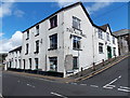
The Squirrel, Pontycymer
The large white building on the corner of Oxford Street and Alexandra Road is stated in various online sources to be a pub, but whether that is still so here in early September 2014 looks unlikely.
The Oxford Street side (on the left) appears to be (or to have been) in use as an unnamed shop.
Image: © Jaggery
Taken: 1 Sep 2014
0.06 miles
9
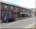
Oxford Street shops near the corner of Alexandra Road, Pontycymer
Looking towards The Squirrel. http://www.geograph.org.uk/photo/4149340 The only other business name in view is R&B Barbers, centre right.
Image: © Jaggery
Taken: 1 Sep 2014
0.06 miles
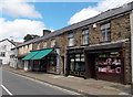
10
Blodau Cwm Garw in Pontycymer
Blodau Cwm Garw on the left is a florist and giftware shop at 21-25 Oxford Street.
Clive Morgan Roberts next door is a shoe shop.
Image: © Jaggery
Taken: 1 Sep 2014
0.06 miles