IMAGES TAKEN NEAR TO
Railway Terrace, BRIDGEND, CF32 8EB
Introduction
This page details the photographs taken nearby to Railway Terrace, CF32 8EB by members of the Geograph project.
The Geograph project started in 2005 with the aim of publishing, organising and preserving representative images for every square kilometre of Great Britain, Ireland and the Isle of Man.

There are currently over 7.5m images from over14,400 individuals and you can help contribute to the project by visiting https://www.geograph.org.uk
Image Map
Images are licensed for reuse under creativecommons.org/licenses/by-sa/2.0
Notes
- Clicking on the map will re-center to the selected point.
- The higher the marker number, the further away the image location is from the centre of the postcode.
Image Listing (117 Images Found)
Images are licensed for reuse under creativecommons.org/licenses/by-sa/2.0
Image
Details
Distance
1
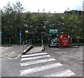
Donation banks in Pontycymer
Located at the western edge of the Co-operative Food store site. http://www.geograph.org.uk/photo/4149748 The Salvation Army green bin is for donations of clothing & shoes. "Your donations help us support people in need. Thank you."
The British Heart Foundation red bin is for donations of good-quality clothing, shoes, accessories, handbags, books, CDs and DVDs. "Thank you. 100% profits to help fight heart disease."
Image: © Jaggery
Taken: 1 Sep 2014
0.03 miles
2
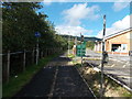
Path past the edge of the Co-operative Food store in Pontycymer
The path is along the western edge of the store. http://www.geograph.org.uk/photo/4149748
Left half of the path for cyclists, right half for walkers.
The fence on the left is at the edge of a drop down to a river, the Afon Garw.
Image: © Jaggery
Taken: 1 Sep 2014
0.04 miles
3
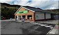
The Co-operative Food store in Pontycymer
Set back from the west side of the A4064 Victoria Street.
Image: © Jaggery
Taken: 1 Sep 2014
0.05 miles
4
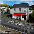
Ladbrokes betting shop in Pontycymer
Viewed across the A4064.
Image: © Jaggery
Taken: 1 Sep 2014
0.05 miles
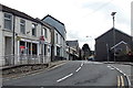
6
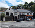
East side of The Square in Pontycymer
Ffaldau Square (or The Square) is an area around the junction of the A4064 and Commercial Place.
Now (2014) closed down, Station Cafe on the left was seen in the film Very Annie Mary, featuring actors Ioan Gruffudd and Matthew Rhys, who were shown serving behind the counter.
Also in view are a shop with the nameboard Glynis, and Ossie's Fish & Chips shop. http://www.geograph.org.uk/photo/4149991
Image: © Jaggery
Taken: 1 Sep 2014
0.05 miles
7
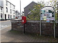
Community noticeboard and postbox in Pontycymer
On the west side of Oxford Street, opposite the post office. The postbox was installed when the large postbox in the post office wall was removed to make space for the installation of a cash dispenser. http://www.geograph.org.uk/photo/4150030
Image: © Jaggery
Taken: 1 Sep 2014
0.06 miles
8
Pontycymer Post Office
Viewed across the A4064 Oxford Street.
Image: © Jaggery
Taken: 1 Sep 2014
0.06 miles
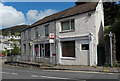
9
Pontycymer Post Office
Viewed across the A4064 Oxford Street. The cash dispenser on the left side of the post office is in the space formerly occupied by a large postbox. A new postbox was installed alongside a community noticeboard http://www.geograph.org.uk/photo/4150019 on the opposite side of Oxford Street.
Image: © Jaggery
Taken: 1 Sep 2014
0.06 miles
10
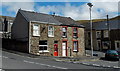
Semi-detached houses on a corner in Pontycymer
On the corner of the A4064 and Waun Bant.
Image: © Jaggery
Taken: 1 Sep 2014
0.06 miles