IMAGES TAKEN NEAR TO
Pontyrhyl, BRIDGEND, CF32 8EA
Introduction
This page details the photographs taken nearby to CF32 8EA by members of the Geograph project.
The Geograph project started in 2005 with the aim of publishing, organising and preserving representative images for every square kilometre of Great Britain, Ireland and the Isle of Man.

There are currently over 7.5m images from over14,400 individuals and you can help contribute to the project by visiting https://www.geograph.org.uk
Image Map
Images are licensed for reuse under creativecommons.org/licenses/by-sa/2.0
Notes
- Clicking on the map will re-center to the selected point.
- The higher the marker number, the further away the image location is from the centre of the postcode.
Image Listing (17 Images Found)
Images are licensed for reuse under creativecommons.org/licenses/by-sa/2.0
Image
Details
Distance
1
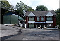
Two sheep near a bus depot in Pontycymer
Sheep walk away from the bus depot on the left, set back from the east side of Nantyrychain Terrace.
Image: © Jaggery
Taken: 6 Sep 2014
0.18 miles
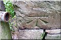
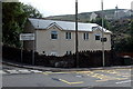
2
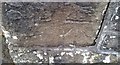
Ordnance Survey Cut Mark
This OS cut mark can be found on the wall of No15 Church Street. It marks a point 197.895m above mean sea level.
Image: © Adrian Dust
Taken: 29 May 2017
0.20 miles
3
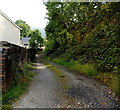
Track in Pant-y-Gog
The track heads east away from the A4064 Pant-y-Gog, opposite Gloucester Buildings. http://www.geograph.org.uk/photo/4153914
Image: © Jaggery
Taken: 6 Sep 2014
0.21 miles
4
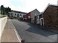
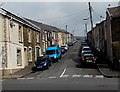
Unnamed street up to Nantyrychain Terrace, Pontycymer
Viewed from Oxford Street.
Image: © Jaggery
Taken: 6 Sep 2014
0.21 miles
5
Pant Street, Pant-y-Gog
Pant Street climbs away from the A4064, opposite New Street.
Image: © Jaggery
Taken: 6 Sep 2014
0.21 miles
6
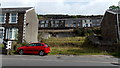
Gap in the houses, Oxford Street, Pontycymer
The empty site is on the east side of Oxford Street. Nantyrychain Terrace houses are in the background. There is no gap in the numbering of adjacent houses, which suggests that a usually unnumbered building, such as a church or chapel, used to be here.
Image: © Jaggery
Taken: 6 Sep 2014
0.21 miles
7
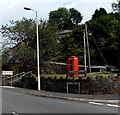
Red phonebox near the southern edge of Pontycymer
On the corner of the A4064 Oxford Street and Nantyrychain Terrace.
The Pontycymer boundary sign is on the left.
Image: © Jaggery
Taken: 6 Sep 2014
0.21 miles
8
Ordnance Survey Cut Mark
This OS cut mark can be found on the wall angle on Nantyrychain Terrace. It marks a point 164.833m above mean sea level.
Image: © Adrian Dust
Taken: 29 May 2017
0.21 miles
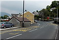
9
Welcome to Pant-y-Gog
Located alongside the A4064 near the southern boundary of Pontycymer. The map I was using showed Pant-y-Gog only as the name of the A4064 SW of Oxford Street in Pontycymer, so I was surprised to see this village-like boundary sign.
Image: © Jaggery
Taken: 6 Sep 2014
0.22 miles
10
Pant-y-Gog bus stops
Bilingual yellow text on the surface of the A4064 shows BUS STOP and the Welsh SAFLE BYSIAU.
The Pontycymer southern boundary sign http://www.geograph.org.uk/photo/4153895 is behind the red phonebox.
Image: © Jaggery
Taken: 6 Sep 2014
0.22 miles