IMAGES TAKEN NEAR TO
Fenton Place, BRIDGEND, CF32 8DN
Introduction
This page details the photographs taken nearby to Fenton Place, CF32 8DN by members of the Geograph project.
The Geograph project started in 2005 with the aim of publishing, organising and preserving representative images for every square kilometre of Great Britain, Ireland and the Isle of Man.

There are currently over 7.5m images from over14,400 individuals and you can help contribute to the project by visiting https://www.geograph.org.uk
Image Map
Images are licensed for reuse under creativecommons.org/licenses/by-sa/2.0
Notes
- Clicking on the map will re-center to the selected point.
- The higher the marker number, the further away the image location is from the centre of the postcode.
Image Listing (48 Images Found)
Images are licensed for reuse under creativecommons.org/licenses/by-sa/2.0
Image
Details
Distance
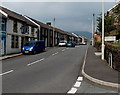
1
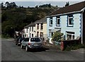
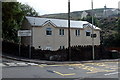
Fenton Place houses, Pontycymer
Viewed from the Oxford Street end looking into the Garw Valley.
Beyond the row of houses is Pontycymer Telephone Exchange. http://www.geograph.org.uk/photo/4153430
Image: © Jaggery
Taken: 6 Sep 2014
0.02 miles
2
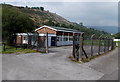
Pontycymer Telephone Exchange
Viewed from Fenton Place. The building is at the edge of Blandy Park football ground. http://www.geograph.org.uk/photo/4153421
Image: © Jaggery
Taken: 6 Sep 2014
0.02 miles
3
Electricity substation in Fenton Place, Pontycymer
The identifier on the Western Power Distribution electricity substation is PANT-Y-GOG S/S 563637.
Image: © Jaggery
Taken: 6 Sep 2014
0.02 miles
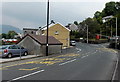
4
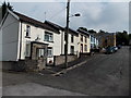
Fenton Place, Pontycymer
Houses on the north side of Fenton Place, viewed looking up towards Oxford Street.
Image: © Jaggery
Taken: 6 Sep 2014
0.03 miles
5
Southern boundary of Pontycymer
The A4064 Pant-y-Gog behind the camera becomes the A4064 Oxford Street ahead.
Image: © Jaggery
Taken: 6 Sep 2014
0.04 miles
7
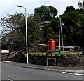
Red phonebox near the southern edge of Pontycymer
On the corner of the A4064 Oxford Street and Nantyrychain Terrace.
The Pontycymer boundary sign is on the left.
Image: © Jaggery
Taken: 6 Sep 2014
0.04 miles
8
Pant-y-Gog bus stops
Bilingual yellow text on the surface of the A4064 shows BUS STOP and the Welsh SAFLE BYSIAU.
The Pontycymer southern boundary sign http://www.geograph.org.uk/photo/4153895 is behind the red phonebox.
Image: © Jaggery
Taken: 6 Sep 2014
0.04 miles
9
Welcome to Pant-y-Gog
Located alongside the A4064 near the southern boundary of Pontycymer. The map I was using showed Pant-y-Gog only as the name of the A4064 SW of Oxford Street in Pontycymer, so I was surprised to see this village-like boundary sign.
Image: © Jaggery
Taken: 6 Sep 2014
0.04 miles
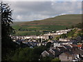
10
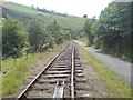
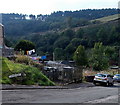
Disused railway line
Since the last colliery closed in the Garw Valley, the mineral line that ran its length saw little need of continuation. Listed as "Disused" on maps, much of the railway track has been lifted as can be seen here.
Image: © Hywel Williams
Taken: 15 Aug 2009
0.06 miles