1
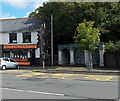
Pontycymer Post Office
Viewed across the A4064 Oxford Street.
Image: © Jaggery
Taken: 1 Sep 2014
0.00 miles
2
Pontycymer Post Office
Viewed across the A4064 Oxford Street. The cash dispenser on the left side of the post office is in the space formerly occupied by a large postbox. A new postbox was installed alongside a community noticeboard http://www.geograph.org.uk/photo/4150019 on the opposite side of Oxford Street.
Image: © Jaggery
Taken: 1 Sep 2014
0.00 miles
3
Community noticeboard and postbox in Pontycymer
On the west side of Oxford Street, opposite the post office. The postbox was installed when the large postbox in the post office wall was removed to make space for the installation of a cash dispenser. http://www.geograph.org.uk/photo/4150030
Image: © Jaggery
Taken: 1 Sep 2014
0.01 miles
4
The Squirrel, Pontycymer
The large white building on the corner of Oxford Street and Alexandra Road is stated in various online sources to be a pub, but whether that is still so here in early September 2014 looks unlikely.
The Oxford Street side (on the left) appears to be (or to have been) in use as an unnamed shop.
Image: © Jaggery
Taken: 1 Sep 2014
0.02 miles
5
Ordnance Survey Cut Mark
This OS cut mark can be found on No5 Oxford Street. It marks a point 156.021m above mean sea level.
Image: © Adrian Dust
Taken: 29 May 2017
0.02 miles
6
Oxford Street shops near the corner of Alexandra Road, Pontycymer
Looking towards The Squirrel. http://www.geograph.org.uk/photo/4149340 The only other business name in view is R&B Barbers, centre right.
Image: © Jaggery
Taken: 1 Sep 2014
0.02 miles
7
East side of The Square in Pontycymer
Ffaldau Square (or The Square) is an area around the junction of the A4064 and Commercial Place.
Now (2014) closed down, Station Cafe on the left was seen in the film Very Annie Mary, featuring actors Ioan Gruffudd and Matthew Rhys, who were shown serving behind the counter.
Also in view are a shop with the nameboard Glynis, and Ossie's Fish & Chips shop. http://www.geograph.org.uk/photo/4149991
Image: © Jaggery
Taken: 1 Sep 2014
0.02 miles
8
Ossie's Fish & Chips in Pontycymer
Located at 2 Oxford Street. A distinctive bus shelter is on the right.
Image: © Jaggery
Taken: 1 Sep 2014
0.02 miles
9
Pontycymmer Clinic in Pontycymer
Viewed across Alexandra Road. The bilingual name board shows the Welsh name of the village, Pontycymer and its English form Pontycymmer. In recent years, the spelling Pontycymer has become prevalent in English use.
The inscription shows the original usage of the building erected in 1939. M and CW Clinic was a Maternity and Child Welfare Clinic. Ogmore and Garw UDC was an Urban District Council formed in 1894. It ceased to exist on March 31st 1974, and was merged with the Urban Districts of Bridgend, Maesteg, Porthcawl (and Penybont Rural District) to form Ogwr (later Bridgend) Borough Council.
The area became part of Bridgend County Borough in 1996.
Image: © Jaggery
Taken: 1 Sep 2014
0.03 miles
10
Down Alexandra Road Pontycymer
Viewed from the edge of Gelliron Cemetery, Alexandra Road descends towards Oxford Street.
Image: © Jaggery
Taken: 6 Sep 2014
0.03 miles


