IMAGES TAKEN NEAR TO
Railway Terrace, BRIDGEND, CF32 8AT
Introduction
This page details the photographs taken nearby to Railway Terrace, CF32 8AT by members of the Geograph project.
The Geograph project started in 2005 with the aim of publishing, organising and preserving representative images for every square kilometre of Great Britain, Ireland and the Isle of Man.

There are currently over 7.5m images from over14,400 individuals and you can help contribute to the project by visiting https://www.geograph.org.uk
Image Map
Images are licensed for reuse under creativecommons.org/licenses/by-sa/2.0
Notes
- Clicking on the map will re-center to the selected point.
- The higher the marker number, the further away the image location is from the centre of the postcode.
Image Listing (78 Images Found)
Images are licensed for reuse under creativecommons.org/licenses/by-sa/2.0
Image
Details
Distance
1
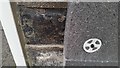
Ordnance Survey Cut Mark
Only the end of the left arrow can be seen. This will soon be lost. This OS cut mark can (at the moment) be found on the south face of No25 Railway Terrace. It marks a point 208.538m above mean sea level.
Image: © Adrian Dust
Taken: 29 May 2017
0.01 miles
2
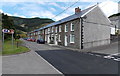
Railway Terrace, Blaengarw
Looking NE from Gwendoline Street. The corner of Cross Street is on the right.
The brown sign points left towards Parc Calon Lân.
Image: © Jaggery
Taken: 15 Aug 2014
0.03 miles
3
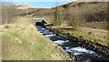
Track to the river from Railway Terrace, Blaengarw
Looking towards the Afon Garw.
Image: © Jaggery
Taken: 15 Aug 2014
0.04 miles
4
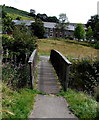
Wooden footbridge over the Afon Garw, Blaengarw
Looking east towards Railway Terrace.
Image: © Jaggery
Taken: 15 Aug 2014
0.04 miles
5
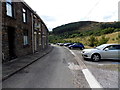
Cars and houses, Railway Terrace, Blaengarw
About 40 metres to the right of the parked cars is a river, Afon Garw.
Image: © Jaggery
Taken: 15 Aug 2014
0.04 miles
6
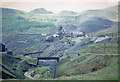
International Colliery, Blaengarw, 1962
View northward, at the head of Cwm Garw: Industrial South Wales as it was 50 years ago. Behind is Mynydd Caerau (1,823 ft.)
Image: © Ben Brooksbank
Taken: 1 Jun 1962
0.04 miles
7
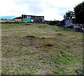
Rusty hillside shack, Blaengarw
Above the east side of Blaengarw Road.
Image: © Jaggery
Taken: 15 Aug 2014
0.05 miles
8
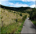
Garw Valley Trail, Blaengarw
Looking north from near this http://www.geograph.org.uk/photo/4130643 footbridge over the Afon Garw.
Image: © Jaggery
Taken: 15 Aug 2014
0.05 miles
9
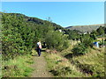
Llwybr ym Mlaengarw / Path in Blaengarw
Cerddwyr yn dilyn llwybr ym Mlaengarw.
Walkers following a path in Blaengarw (trans. source of the Garw [river]).
Image: © Alan Richards
Taken: 25 Aug 2019
0.05 miles