IMAGES TAKEN NEAR TO
David Street, BRIDGEND, CF32 8AD
Introduction
This page details the photographs taken nearby to David Street, CF32 8AD by members of the Geograph project.
The Geograph project started in 2005 with the aim of publishing, organising and preserving representative images for every square kilometre of Great Britain, Ireland and the Isle of Man.

There are currently over 7.5m images from over14,400 individuals and you can help contribute to the project by visiting https://www.geograph.org.uk
Image Map
Images are licensed for reuse under creativecommons.org/licenses/by-sa/2.0
Notes
- Clicking on the map will re-center to the selected point.
- The higher the marker number, the further away the image location is from the centre of the postcode.
Image Listing (86 Images Found)
Images are licensed for reuse under creativecommons.org/licenses/by-sa/2.0
Image
Details
Distance
1
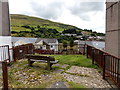
Bench with a view, Blaengarw
In a gap between houses on the south side of Herbert Street.
http://www.geograph.org.uk/photo/4144212 to a view from the bench
Image: © Jaggery
Taken: 15 Aug 2014
0.02 miles
2
Herbert Street, Blaengarw
Looking towards Bryn-Bedw Street from near The Strand.
Image: © Jaggery
Taken: 15 Aug 2014
0.02 miles
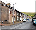
3
David Street, Blaengarw
Viewed from the eastern end of the street, looking towards the A4064 Nanthir Road.
The trees are on the bank of a stream, Nant Hir.
Image: © Jaggery
Taken: 15 Aug 2014
0.02 miles
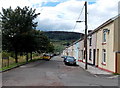
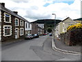
4
West along Bryn-Bedw Street, Blaengarw
Viewed from the eastern end of the street, where the road bends into David Street. For about 45 metres, there are no houses on the left side of Bryn-Bedw Street, because the land is occupied by the rear gardens of David Street houses.
Image: © Jaggery
Taken: 15 Aug 2014
0.04 miles
5
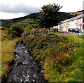
Downstream along Nant Hir, Blaengarw
The stream flows away from this http://www.geograph.org.uk/photo/4144295 footbridge. David Street is on the right.
Image: © Jaggery
Taken: 15 Aug 2014
0.04 miles
6
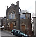
Former Bethania Welsh Baptist Church, Blaengarw
Viewed across Herbert Street. Now (2014) disused and partly fenced off,
this is the 1912 rebuild of the original Bethania dating from 1890.
Image: © Jaggery
Taken: 15 Aug 2014
0.04 miles
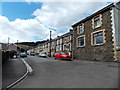
7
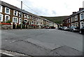
Junction in Blaengarw
Herbert Street on the right, Bryn-Bedw Street on the left.
Image: © Jaggery
Taken: 15 Aug 2014
0.04 miles
8
Down Herbert Street, Blaengarw
Viewed from the corner of Bryn-Bedw Street. Herbert Street descends towards The Strand.
Image: © Jaggery
Taken: 15 Aug 2014
0.05 miles
9
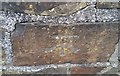
Ordnance Survey Cut Mark
This OS cut mark can be found on the wall NW of the road junction. It marks a point 216.295m above mean sea level.
Image: © Adrian Dust
Taken: 29 May 2017
0.06 miles
10
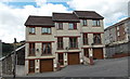
Three three-storey modern houses in Blaengarw
On the corner of The Strand and Herbert Street.
Image: © Jaggery
Taken: 15 Aug 2014
0.07 miles