IMAGES TAKEN NEAR TO
Aber Houses, BRIDGEND, CF32 7SL
Introduction
This page details the photographs taken nearby to Aber Houses, CF32 7SL by members of the Geograph project.
The Geograph project started in 2005 with the aim of publishing, organising and preserving representative images for every square kilometre of Great Britain, Ireland and the Isle of Man.

There are currently over 7.5m images from over14,400 individuals and you can help contribute to the project by visiting https://www.geograph.org.uk
Image Map
Images are licensed for reuse under creativecommons.org/licenses/by-sa/2.0
Notes
- Clicking on the map will re-center to the selected point.
- The higher the marker number, the further away the image location is from the centre of the postcode.
Image Listing (72 Images Found)
Images are licensed for reuse under creativecommons.org/licenses/by-sa/2.0
Image
Details
Distance
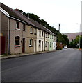
1
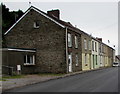
Aber Road houses in Nantymoel
Row of houses on the east side of the A4061 Aber Road at the southern edge of Nantymoel.
Image: © Jaggery
Taken: 4 Oct 2018
0.00 miles
2
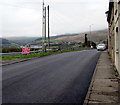
Aber Road enters Nantymoel
The A4061 Aber Road from Ogmore Vale passes the southern boundary sign for Nantymoel.
The sign https://www.geograph.org.uk/photo/5929696 shows Nant-y-moel, the Welsh name of the village usually spelt Nantymoel in English.
Image: © Jaggery
Taken: 4 Oct 2018
0.01 miles
3
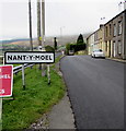
Southern boundary of Nantymoel
The sign alongside the A4061 Aber Road shows the Welsh name of the village usually spelt Nantymoel in English.
Image: © Jaggery
Taken: 4 Oct 2018
0.02 miles
4
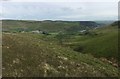
Ogwr Valley
View along the Ogwr valley from Pricetown to Ogmore Vale.
Image: © Alan Hughes
Taken: 18 May 2017
0.03 miles
5
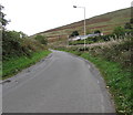
Unclassified road ascending from Wyndham towards Nantymoel
Ascending from the valley of the Ogwr Fawr river towards the A4061 at the southern edge of Nantymoel.
Image: © Jaggery
Taken: 4 Oct 2018
0.03 miles
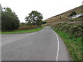
6
Houses at southern edge of Nantymoel
On the east side of the A4061 Aber Road. Beyond the houses the 30mph speed limit increases to 40mph.
Image: © Jaggery
Taken: 4 Oct 2018
0.04 miles
7

Wyndham and the lane from the A4061 Ogmore valley road
Cwm Ogwr (the Ogmore valley) is steep-sided but has several villages along its length.
Image: © Andrew Hill
Taken: 20 Oct 2008
0.04 miles
8
Hillside above Aber Road, Nantymoel
Above the east side of the A4061 Aber Road at the southern edge of Nantymoel viewed in early October 2018.
Image: © Jaggery
Taken: 4 Oct 2018
0.04 miles
9
Junction between Wyndham and Nantymoel
On the left, the access road to Aber Field sports ground diverges from
the unclassified road ascending from Wyndham to the A4061 in Nantymoel.
Image: © Jaggery
Taken: 4 Oct 2018
0.05 miles
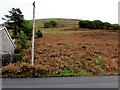
10
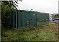
Wales & West Utilities gas installation at the southern edge of Nantymoel
Alongside the A4061 Aber Road.
Image: © Jaggery
Taken: 4 Oct 2018
0.06 miles