IMAGES TAKEN NEAR TO
Commercial Street, BRIDGEND, CF32 7RA
Introduction
This page details the photographs taken nearby to Commercial Street, CF32 7RA by members of the Geograph project.
The Geograph project started in 2005 with the aim of publishing, organising and preserving representative images for every square kilometre of Great Britain, Ireland and the Isle of Man.

There are currently over 7.5m images from over14,400 individuals and you can help contribute to the project by visiting https://www.geograph.org.uk
Image Map
Images are licensed for reuse under creativecommons.org/licenses/by-sa/2.0
Notes
- Clicking on the map will re-center to the selected point.
- The higher the marker number, the further away the image location is from the centre of the postcode.
Image Listing (60 Images Found)
Images are licensed for reuse under creativecommons.org/licenses/by-sa/2.0
Image
Details
Distance
1
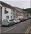
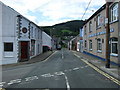
On-street parking, Commercial Street, Nantymoel
Parking allowed on the left. Double yellow lines on the right indicate no parking at any time.
Image: © Jaggery
Taken: 29 Aug 2018
0.00 miles
2

Up Commercial Street, Nantymoel
Commercial Street ascends to the southeast past a Londis convenience store https://www.geograph.org.uk/photo/5888777
Image: © Jaggery
Taken: 29 Aug 2018
0.00 miles
3
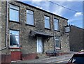
Formerly the Nantymoel Hotel
In its heyday a convenient hotel close to the railway station. Now, yet another sign of a run-down valleys community. A close look at the pub sign reveals the remaining letters of Welsh Brewers (above) and Nantymoel (below).
Image: © Alan Hughes
Taken: 3 Sep 2023
0.01 miles
4
Nantymoel Hotel, Commercial Street, Nantymoel
Pub viewed in August 2018. The banner on the wall shows
Large Screen Premier League Football - All Sports Here Now - Support Your Local Pub and Team!
Image: © Jaggery
Taken: 29 Aug 2018
0.02 miles
5
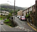
Junction of Commercial Street and Station Road, Nantymoel
Commercial Street descends past the southeast end of Station Road. Old maps show Nantymoel railway station nearby, out of shot on the left, on flat land near the River Ogmore. The station closed down in 1958.
Image: © Jaggery
Taken: 29 Aug 2018
0.02 miles
6
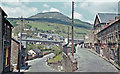
Ogmore Valley: Nant-y-moel A4061, 1962
View NW to Werfa (1,865 ft.) Junction of Commercial Street (an off-shoot of the A4061 terminating at the station on the left) and Station Road. The line closed in May 1958.
Image: © Ben Brooksbank
Taken: 1 Jun 1962
0.03 miles
7
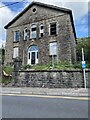
Bethel Chapel, Nantymoel
Another sign of the depressed condition of the Welsh valleys. The chapel, built in 1877, is steadily deteriorating despite plans 15 years ago to turn it into a residential care home.
Image: © Alan Hughes
Taken: 3 Sep 2023
0.03 miles
8

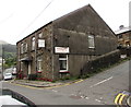
Derelict former Bethel Chapel, Commercial Street, Nantymoel
This is the 1872 rebuild of the original chapel erected in 1867.
The building and site appear long derelict in August 2018.
Image: © Jaggery
Taken: 29 Aug 2018
0.03 miles
9
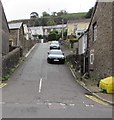
Steep ascent from Commercial Street, Nantymoel
A side road ascends towards Church Terrace.
Image: © Jaggery
Taken: 29 Aug 2018
0.04 miles
10
Nant-y-Moel Post Office
Post Office in Commercial Street, opposite the Nant-y-Moel Social Club and Institute.
Image: © Colin Pyle
Taken: 22 Aug 2008
0.04 miles