IMAGES TAKEN NEAR TO
Gwendoline Street, BRIDGEND, CF32 7PL
Introduction
This page details the photographs taken nearby to Gwendoline Street, CF32 7PL by members of the Geograph project.
The Geograph project started in 2005 with the aim of publishing, organising and preserving representative images for every square kilometre of Great Britain, Ireland and the Isle of Man.

There are currently over 7.5m images from over14,400 individuals and you can help contribute to the project by visiting https://www.geograph.org.uk
Image Map
Images are licensed for reuse under creativecommons.org/licenses/by-sa/2.0
Notes
- Clicking on the map will re-center to the selected point.
- The higher the marker number, the further away the image location is from the centre of the postcode.
Image Listing (81 Images Found)
Images are licensed for reuse under creativecommons.org/licenses/by-sa/2.0
Image
Details
Distance
1

Road to Nantymoel Primary School, Nantymoel
Descending from the west side of the A4061 Ogwy Street towards
an entrance gate to Nantymoel Primary School in Gwendoline Street.
Image: © Jaggery
Taken: 29 Aug 2018
0.03 miles
2

North along Park Street, Nantymoel
Cul-de-sac accessed from the A4061 Ogwy Street.
Image: © Jaggery
Taken: 29 Aug 2018
0.04 miles

4
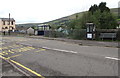
Ogwy Street towards the Blaenogwr in Nantymoel
Looking south along the A4061 Ogwy Street past a bench, phonebox
and bus stop & shelter towards the Blaenogwr pub & hotel. https://www.geograph.org.uk/photo/5887677
Image: © Jaggery
Taken: 29 Aug 2018
0.05 miles
5
N.A.W.S. charity shop, Ogwy Street, Nantymoel
Viewed across the A4061. N.A.W.S. is the acronym of Nantymoel Animal Welfare Society.
Image: © Jaggery
Taken: 29 Aug 2018
0.06 miles
6
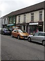
Anne's Plaice, 12 Ogwy Street, Nantymoel
Fish & chips shop viewed across the A4061 in August 2018.
A June 2011 Google Earth Street View shows Wayne's Plaice fish & chips shop here.
Image: © Jaggery
Taken: 29 Aug 2018
0.06 miles
7
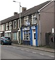
Nantymoel Pharmacy, 22 Ogwy Street, Nantymoel
Behind the yellow car, the Nantymoel Pharmacy nameboard shows G Rowe Services Ltd and NUMARK.
In August 2018, the Barber Pit on the left is in premises formerly occupied by Nantymoel Post Office.
The village post office is now nearby in the Corner Convenience Store https://www.geograph.org.uk/photo/5887802 at 21 Ogwy Street
Image: © Jaggery
Taken: 29 Aug 2018
0.06 miles
8
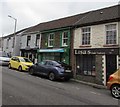
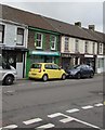
Lisa's Hair Salon, 20 Ogwy Street, Nantymoel
Viewed across the A4061.
Image: © Jaggery
Taken: 29 Aug 2018
0.06 miles
9
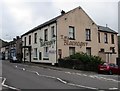
The Blaenogwr in Nantymoel
Pub & hotel at 10 Ogwy Street viewed across the A4061.
Image: © Jaggery
Taken: 29 Aug 2018
0.06 miles
10
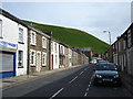
Terraced housing on the A4061, Price Town
Image: © Ruth Sharville
Taken: 23 Jun 2007
0.06 miles