IMAGES TAKEN NEAR TO
Hillside, BRIDGEND, CF32 7LJ
Introduction
This page details the photographs taken nearby to Hillside, CF32 7LJ by members of the Geograph project.
The Geograph project started in 2005 with the aim of publishing, organising and preserving representative images for every square kilometre of Great Britain, Ireland and the Isle of Man.

There are currently over 7.5m images from over14,400 individuals and you can help contribute to the project by visiting https://www.geograph.org.uk
Image Map
Images are licensed for reuse under creativecommons.org/licenses/by-sa/2.0
Notes
- Clicking on the map will re-center to the selected point.
- The higher the marker number, the further away the image location is from the centre of the postcode.
Image Listing (34 Images Found)
Images are licensed for reuse under creativecommons.org/licenses/by-sa/2.0
Image
Details
Distance
1

Across the Ogwr Valley toward Pont-yr-awel
Image: © Mick Lobb
Taken: 22 Oct 2008
0.04 miles
2
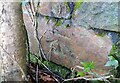
Ordnance Survey Cut Mark
This OS cut mark can be found on the wall at the road junction. It marks a point 124.377m above mean sea level.
Image: © Adrian Dust
Taken: 27 Feb 2021
0.06 miles
3

Looking down on Pant-yr-awal
A fine view across the Ogwr/Ogmore Valley from the road crossing to the Garw valley.
Image: © Andrew Hill
Taken: 21 Oct 2008
0.10 miles
4
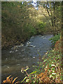
A glimpse of the River Ogmore near Pant-yr-awel
A short and rather narrow stretch of the Ogwr Fawr viewed from beside the Ogmore Valley cycle path. The Ogwr Fawr is one of the two upper branches of the River Ogmore/Afon Ogwr, the other being the Ogwr Fach. The two meet at Blackmill.
Image: © eswales
Taken: 25 Oct 2013
0.13 miles
5
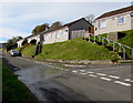
Bungalows above Woodland Terrace, Pant-yr-awel
Accessed by steps on the right or ahead.
Image: © Jaggery
Taken: 31 Oct 2018
0.14 miles
6

View up the Ogmore Valley from Llangeinor Common
Image: © Mick Lobb
Taken: 24 Oct 2008
0.15 miles
7
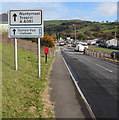
A4061 direction and distances signs alongside the A4093, Pant-yr-awel
Two miles from Ogmore Vale and three miles from Pricetown,
the A4093 from Tonyrefail descends towards the A4061.
Image: © Jaggery
Taken: 31 Oct 2018
0.15 miles
8
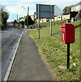
Queen Elizabeth II postbox alongside the A4093 in Pant-yr-awel
Located here. https://www.geograph.org.uk/photo/5959935
Image: © Jaggery
Taken: 31 Oct 2018
0.15 miles
9
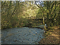
The River Ogmore by Pant-yr-awel
Looking upstream as the river flows under a bridge which once carried the Ogmore Valley’s railway line.
Image: © eswales
Taken: 25 Oct 2013
0.16 miles
10
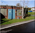
Western Power Distribution electricity substation, Pant-yr-awel
The substation identifier is S/S 563729.
Image: © Jaggery
Taken: 31 Oct 2018
0.16 miles