IMAGES TAKEN NEAR TO
Dunraven Place, BRIDGEND, CF32 7ET
Introduction
This page details the photographs taken nearby to Dunraven Place, CF32 7ET by members of the Geograph project.
The Geograph project started in 2005 with the aim of publishing, organising and preserving representative images for every square kilometre of Great Britain, Ireland and the Isle of Man.

There are currently over 7.5m images from over14,400 individuals and you can help contribute to the project by visiting https://www.geograph.org.uk
Image Map
Images are licensed for reuse under creativecommons.org/licenses/by-sa/2.0
Notes
- Clicking on the map will re-center to the selected point.
- The higher the marker number, the further away the image location is from the centre of the postcode.
Image Listing (80 Images Found)
Images are licensed for reuse under creativecommons.org/licenses/by-sa/2.0
Image
Details
Distance
1
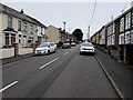
North along Dunraven Place, Wyndham
Part of the main road through the village. Ahead for Nantymoel.
Image: © Jaggery
Taken: 4 Oct 2018
0.01 miles
2
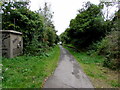
Former railway route, Wyndham
In 2018 this footpath and cycleway is part of National Cycle Network Route 883, a 7km (4 miles) long route on a former railway trackbed from Nantymoel to Blackmill via Ogmore Vale. The remains of the former Wyndham Halt station https://www.geograph.org.uk/photo/5930541 are on the right. An electricity substation https://www.geograph.org.uk/photo/5930570 is on the left.
Image: © Jaggery
Taken: 4 Oct 2018
0.02 miles
3

Wyndham Street electricity substation, Wyndham
The Western Power Distribution electricity substation is set back from a footpath and cycleway east of Wyndham Street. The substation identifier is S/S 563669. The remains of Wyndham Halt railway station are nearby. https://www.geograph.org.uk/photo/5930541
Image: © Jaggery
Taken: 4 Oct 2018
0.02 miles
4

Path past the remains of Wyndham Halt station
A cycle route and footpath through the Ogwr Fawr valley use a former railway route, here past the remains of the platform at Wyndham Halt station which closed in 1958. Opened in 1942, the halt served the village of Wyndham, the Wyndham Colliery and Penllwyngwent Colliery.
Image: © Jaggery
Taken: 4 Oct 2018
0.03 miles
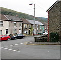
5

Houses between two hillsides, Wyndham
Viewed from steep Coronation Street looking towards houses in Dunraven Place
which is built on the flattish land through the valley of the Ogwr Fawr river.
Image: © Jaggery
Taken: 4 Oct 2018
0.03 miles
6
Telecoms cabinet, Coronation Street, Wyndham
Dark green cabinet on the corner of Dunraven Place.
Image: © Jaggery
Taken: 4 Oct 2018
0.03 miles
7
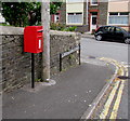
Queen Elizabeth II postbox, Coronation Street, Wyndham
Located here https://www.geograph.org.uk/photo/5928820 on the corner of Dunraven Place.
Image: © Jaggery
Taken: 4 Oct 2018
0.03 miles
8
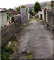
Back lane in Wyndham
On the south side of Coronation Street, between Dunraven Place and Adare Street.
Image: © Jaggery
Taken: 4 Oct 2018
0.03 miles
9
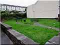
Two benches in a grassy area, Wyndham
Above the west side of Dunraven Place.
Image: © Jaggery
Taken: 4 Oct 2018
0.04 miles
10
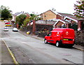
Royal Mail van, Coronation Street, Wyndham
The van's identifier BE23 shows that it is based at Bridgend Delivery Office.
Image: © Jaggery
Taken: 4 Oct 2018
0.05 miles