IMAGES TAKEN NEAR TO
Fronwen Terrace, BRIDGEND, CF32 7ES
Introduction
This page details the photographs taken nearby to Fronwen Terrace, CF32 7ES by members of the Geograph project.
The Geograph project started in 2005 with the aim of publishing, organising and preserving representative images for every square kilometre of Great Britain, Ireland and the Isle of Man.

There are currently over 7.5m images from over14,400 individuals and you can help contribute to the project by visiting https://www.geograph.org.uk
Image Map
Images are licensed for reuse under creativecommons.org/licenses/by-sa/2.0
Notes
- Clicking on the map will re-center to the selected point.
- The higher the marker number, the further away the image location is from the centre of the postcode.
Image Listing (53 Images Found)
Images are licensed for reuse under creativecommons.org/licenses/by-sa/2.0
Image
Details
Distance
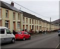
1
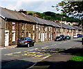
Fronwen Terrace, Ogmore Vale
Long row of houses viewed looking north towards Wyndham.
Image: © Jaggery
Taken: 23 Aug 2018
0.01 miles
2
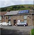
Rooftop solar panels, Fronwen Terrace, Ogmore Vale
Viewed in August 2018. The panels were not here in a June 2011 Google Street View.
Image: © Jaggery
Taken: 23 Aug 2018
0.02 miles
3
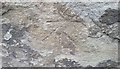
Ordnance Survey Cut Mark
This OS cut mark can be found on No30 Fron Wen Terrace. It marks a point 160.654m above mean sea level.
Image: © Adrian Dust
Taken: 29 May 2017
0.04 miles
4
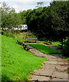
Five benches in Ogmore Vale
Located below the east side of Fronwen Terrace.
Image: © Jaggery
Taken: 23 Aug 2018
0.05 miles
5
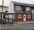
Small bus shelter, Dunraven Place, Wyndham
This side of the road for buses to Nantymoel.
A white-on-red notice on a wooden pole shows SLOW - CHILDREN & ANIMALS.
Image: © Jaggery
Taken: 4 Oct 2018
0.06 miles
6
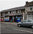
Patels Mini-Market in Wyndham
At 7-9 Dunraven Place.
Image: © Jaggery
Taken: 4 Oct 2018
0.06 miles
7
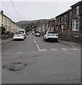
Adare Street, Wyndham
South along Adare Street from Coronation Street.
Image: © Jaggery
Taken: 4 Oct 2018
0.07 miles
8

Entrance to Wyndham Boys and Girls Club, Wyndham
The entrance to this club https://www.geograph.org.uk/photo/5928861 from Dunraven Place. The plaque on the wall is dedicated to the memory of Stanley Reginald Norris MBE (Stan the Man) 1934-2011."An inspiration to us all".
Image: © Jaggery
Taken: 4 Oct 2018
0.08 miles
9
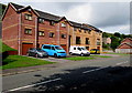
Cwrt Ty Mawr, Ogmore Vale
Modern three-storey housing on the west side of North Road.
On the ground floor are built-in garages.
Image: © Jaggery
Taken: 23 Aug 2018
0.08 miles
10
Long row of houses, Adare Street, Wyndham
Houses on the east side of Adare Street viewed from the corner of Coronation Street.
Image: © Jaggery
Taken: 4 Oct 2018
0.08 miles