IMAGES TAKEN NEAR TO
Walters Road, BRIDGEND, CF32 7DN
Introduction
This page details the photographs taken nearby to Walters Road, CF32 7DN by members of the Geograph project.
The Geograph project started in 2005 with the aim of publishing, organising and preserving representative images for every square kilometre of Great Britain, Ireland and the Isle of Man.

There are currently over 7.5m images from over14,400 individuals and you can help contribute to the project by visiting https://www.geograph.org.uk
Image Map
Images are licensed for reuse under creativecommons.org/licenses/by-sa/2.0
Notes
- Clicking on the map will re-center to the selected point.
- The higher the marker number, the further away the image location is from the centre of the postcode.
Image Listing (94 Images Found)
Images are licensed for reuse under creativecommons.org/licenses/by-sa/2.0
Image
Details
Distance
1
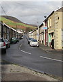
Walters Road, Ogmore Vale
Looking to the NNW along unclassified Walters Road from the corner of the A4061.
The corner shop at 2 Walters Road on the right is Daisy Chains Florist. https://www.geograph.org.uk/photo/5974797
Image: © Jaggery
Taken: 14 Nov 2018
0.01 miles
2
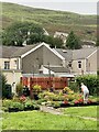
Taking pride
Waste land at the rear of terraced housing in a run-down valley town, and this lady is working hard to improve its appearance.
Image: © Alan Hughes
Taken: 7 Sep 2023
0.01 miles
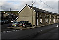
3

Terraced street, Ogmore Vale
Mynydd Llangeinwyr rising beyond.
Image: © Andrew Hill
Taken: 20 Oct 2008
0.02 miles
4
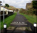
North along cycle route 883, Ogmore Vale
From the A4061 Bridge Street. The notice on the left states that the route ahead is a cycle track and permissive bridleway, part of National Cycle Network Route 883 which here uses the route of a dismantled railway.
Image: © Jaggery
Taken: 14 Nov 2018
0.04 miles
5
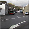
Junction of St John Street and Bridge Street, Ogmore Vale
The southern end of St John Street viewed across the A4061 Bridge Street.
Image: © Jaggery
Taken: 14 Nov 2018
0.05 miles
6
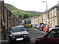
Classic Valleys terraces - with vehicles
These terraced houses can be seen all through the settlements of the Valleys. What they weren't designed for is double parking and the occasional coach, as the car driver next to me was finding out!
Image: © Ruth Sharville
Taken: 23 Jun 2007
0.05 miles
7

Junction of Bridge Street and St John Street, Ogmore Vale
Viewed across the A4061 Bridge Street. The Corbett Arms https://www.geograph.org.uk/photo/6040436 is on the left.
Image: © Jaggery
Taken: 25 Aug 2018
0.06 miles
8

Row of houses, Bridge Street, Ogmore Vale
Viewed across the A4061 Bridge Street on the approach to the St John Street junction.
Image: © Jaggery
Taken: 25 Aug 2018
0.06 miles
9

North side of the Corbett Arms, Bridge Street, Ogmore Vale
Pub viewed across the A4061 Bridge Street.
Image: © Jaggery
Taken: 25 Aug 2018
0.06 miles
10
Row of stone houses, Bridge Street, Ogmore Vale
On the west side of the A4061 Bridge Street.
Houses in St John Street are in the background on the left.
Image: © Jaggery
Taken: 14 Nov 2018
0.06 miles