IMAGES TAKEN NEAR TO
Spion Kop, BRIDGEND, CF32 7BT
Introduction
This page details the photographs taken nearby to Spion Kop, CF32 7BT by members of the Geograph project.
The Geograph project started in 2005 with the aim of publishing, organising and preserving representative images for every square kilometre of Great Britain, Ireland and the Isle of Man.

There are currently over 7.5m images from over14,400 individuals and you can help contribute to the project by visiting https://www.geograph.org.uk
Image Map
Images are licensed for reuse under creativecommons.org/licenses/by-sa/2.0
Notes
- Clicking on the map will re-center to the selected point.
- The higher the marker number, the further away the image location is from the centre of the postcode.
Image Listing (126 Images Found)
Images are licensed for reuse under creativecommons.org/licenses/by-sa/2.0
Image
Details
Distance
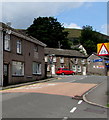
1
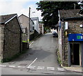
Ardwyn Place, Ogmore Vale
Ascending towards Gorwyl Road. A Lifestyle Express convenience store at 1 Tynewydd Row is on the right. https://www.geograph.org.uk/photo/5880983
Image: © Jaggery
Taken: 23 Aug 2018
0.02 miles
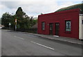
2
Lifestyle Express shop in Ogmore Vale
Convenience store at 1 Tynewydd Row.
Image: © Jaggery
Taken: 23 Aug 2018
0.04 miles
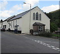
3
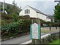
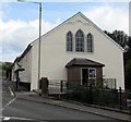
Chapel conversion beside community route at Ogmore Vale
Image: © Mick Lobb
Taken: 16 Sep 2008
0.04 miles
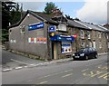
4
G. Clack Carpets & Furniture, 2 Tynewydd Row, Ogmore Vale
Located in the former Ogmore Vale Wesleyan Methodist Chapel built in 1886. https://www.geograph.org.uk/photo/5886548
Image: © Jaggery
Taken: 23 Aug 2018
0.05 miles
5
Up Commercial Street, Ogmore Vale
Commercial Street ascends towards Llywelyn Street and Tynewydd Row.
Image: © Jaggery
Taken: 23 Aug 2018
0.05 miles
6
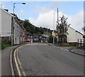
Northwest end of Commercial Street, Ogmore Vale
Commercial Street ascends towards Llywelyn Street and Tynewydd Row.
Image: © Jaggery
Taken: 23 Aug 2018
0.05 miles
7
Yellow defibrillator box on a Tynewydd Row wall, Ogmore Vale
The box contains a defibrillator for use in a potentially life-threatening emergency. The defibrillator applies a therapeutic electric current to the chest or heart to stop irregular contractions, or fibrillation, of the heart.
Viewed in August 2018. The Ogmore Vale R.F.C. (Rugby Football Club) name sign seen on this building in a September 2009 Google Earth Street View has gone.
Image: © Jaggery
Taken: 23 Aug 2018
0.05 miles
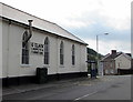
8
Former Wesleyan Methodist Chapel, Ogmore Vale
Located on the corner of Commercial Street and Tynewydd Row, Ogmore Vale Wesleyan Methodist Chapel was built in 1886. In the late 20th century the chapel was converted to G. Clack's furniture and carpet showroom which remains its usage in 2018. https://www.geograph.org.uk/photo/5882532
Image: © Jaggery
Taken: 25 Aug 2018
0.06 miles
9
Former Ogmore Vale Wesleyan Methodist Chapel
Located on the corner of Commercial Street and Tynewydd Row, Ogmore Vale Wesleyan Methodist Chapel was built in 1886. In the late 20th century the chapel was converted to G. Clack's furniture and carpet showroom which remains its usage in 2018. https://www.geograph.org.uk/photo/5882532
Image: © Jaggery
Taken: 23 Aug 2018
0.06 miles
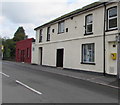
10
Heddfan Funeral Home, Tynewydd Row, Ogmore Vale
C & O J Sendell funeral services.
Image: © Jaggery
Taken: 23 Aug 2018
0.06 miles