IMAGES TAKEN NEAR TO
River Street, BRIDGEND, CF32 7BH
Introduction
This page details the photographs taken nearby to River Street, CF32 7BH by members of the Geograph project.
The Geograph project started in 2005 with the aim of publishing, organising and preserving representative images for every square kilometre of Great Britain, Ireland and the Isle of Man.

There are currently over 7.5m images from over14,400 individuals and you can help contribute to the project by visiting https://www.geograph.org.uk
Image Map
Images are licensed for reuse under creativecommons.org/licenses/by-sa/2.0
Notes
- Clicking on the map will re-center to the selected point.
- The higher the marker number, the further away the image location is from the centre of the postcode.
Image Listing (148 Images Found)
Images are licensed for reuse under creativecommons.org/licenses/by-sa/2.0
Image
Details
Distance
1
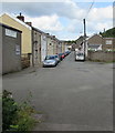
North along River Street, Ogmore Vale
Towards Commercial Street.
Image: © Jaggery
Taken: 25 Aug 2018
0.02 miles
2

South along National Cycle Network Route 883, Ogmore Vale
Former railway route viewed across Commercial Street, Ogmore Vale.
The remains https://www.geograph.org.uk/photo/6162110 of the former Ogmore Vale station are behind the camera.
Image: © Jaggery
Taken: 23 Aug 2018
0.02 miles
3
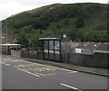
Llywelyn Street bus stop and shelter, Ogmore Vale
The shelter looks like it gives little protection from inclement weather.
Image: © Jaggery
Taken: 25 Aug 2018
0.03 miles
4
Ogmore Vale Dental Surgery
Dental clinic at 14 Commercial Street, Ogmore Vale.
Image: © Jaggery
Taken: 23 Aug 2018
0.03 miles
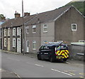
5
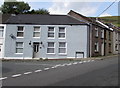
River Street house on the corner of Commercial Street, Ogmore Vale
The river in question is the Ogmore. https://www.geograph.org.uk/photo/5880961
Image: © Jaggery
Taken: 23 Aug 2018
0.03 miles
6
SSE Enterprise Rail van, Llywelyn Street, Ogmore Vale
SSE Enterprise has six business units providing business energy, energy management, utility networks, contracting, rail, and telecoms services to its customers. SSE Enterprise works with customers and suppliers to reduce carbon emissions and cut energy bills, helping organisations of all sizes move towards a more sustainable future. The word Rail is on the side of this van.
Image: © Jaggery
Taken: 25 Aug 2018
0.03 miles
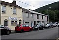
7
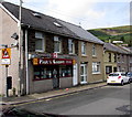
Paul's Chippy in Ogmore Vale
Traditional fish & chips shop at 24 Commercial Street Ogmore Vale.
Image: © Jaggery
Taken: 23 Aug 2018
0.03 miles

9
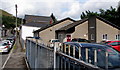
Ogmore Vale Surgery, Ogmore Vale
Medical surgery in Commercial Street, Ogmore Vale.
Image: © Jaggery
Taken: 23 Aug 2018
0.04 miles
10
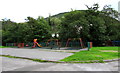
Children's playground in Ogmore Vale
Located between River Street and the Ogwr Fawr river.
Image: © Jaggery
Taken: 25 Aug 2018
0.04 miles