IMAGES TAKEN NEAR TO
Glyn Street, BRIDGEND, CF32 7AS
Introduction
This page details the photographs taken nearby to Glyn Street, CF32 7AS by members of the Geograph project.
The Geograph project started in 2005 with the aim of publishing, organising and preserving representative images for every square kilometre of Great Britain, Ireland and the Isle of Man.

There are currently over 7.5m images from over14,400 individuals and you can help contribute to the project by visiting https://www.geograph.org.uk
Image Map
Images are licensed for reuse under creativecommons.org/licenses/by-sa/2.0
Notes
- Clicking on the map will re-center to the selected point.
- The higher the marker number, the further away the image location is from the centre of the postcode.
Image Listing (146 Images Found)
Images are licensed for reuse under creativecommons.org/licenses/by-sa/2.0
Image
Details
Distance
1
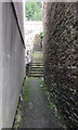
Steps up to Glyn Street, Ogmore Vale
From a path on the east side of High Street.
Image: © Jaggery
Taken: 25 Aug 2018
0.02 miles
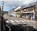
2
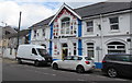
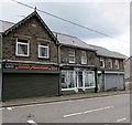
Ogmore Vale Bar & Restaurant, 50 High Street, Ogmore Vale
Elements of the building's history in view in August 2018 include FOX AND HOUNDS and the year 1913.
Image: © Jaggery
Taken: 25 Aug 2018
0.03 miles
3
Ogmore Vale Bar & Restaurant
Formerly the Fox & Hounds Public House this substantial building on the High St is now an Indian Restaurant.
Image: © Steve Barnes
Taken: 7 Oct 2017
0.03 miles
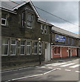
4
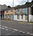
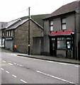
Former post office, High Street, Ogmore Vale
Viewed in late August 2018 when the village post office https://www.geograph.org.uk/photo/5883052 is elsewhere in High Street.
Image: © Jaggery
Taken: 25 Aug 2018
0.03 miles
5
Zebra crossing, High Street, Ogmore Vale
Across the A4061, here named High Street Ogmore Vale. The village post office is on the right.
Image: © Jaggery
Taken: 25 Aug 2018
0.03 miles
6
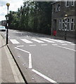
Zebra crossing in Ogmore Vale
Across the A4061 High Street in Ogmore Vale.
Image: © Jaggery
Taken: 25 Aug 2018
0.03 miles
7
LiteBite Cafe in Ogmore Vale
At 42 High Street.
Image: © Jaggery
Taken: 25 Aug 2018
0.03 miles
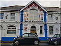
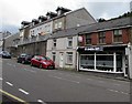
8
Ogmore Vale Constitutional Club
Club on the west side of the A4061 High Street in Ogmore Vale.
The older name on a first floor window is OGMORE VALE CONSTITUTIONAL CLUB.
The newer name on the right is OGMORE VALE CON CLUB.
Image: © Jaggery
Taken: 25 Aug 2018
0.03 miles
9
Anns Flowers, 55 High Street, Ogmore Vale
In late August 2018 Anns Flowers nameboard shows Flowers - Fruit & Veg - Pet Supplies. A June 2011 Google Earth Street View shows Skruffy's professional dog grooming & pet supplies shop at 55 High Street. Glam Hair Studio is next door, as it was in June 2011.
Image: © Jaggery
Taken: 25 Aug 2018
0.04 miles
10
Po Wing in Ogmore Vale
Po Wing Chinese takeaway at 45 High Street Ogmore Vale.
Image: © Jaggery
Taken: 25 Aug 2018
0.04 miles