IMAGES TAKEN NEAR TO
Aber Lane, BRIDGEND, CF32 7AQ
Introduction
This page details the photographs taken nearby to Aber Lane, CF32 7AQ by members of the Geograph project.
The Geograph project started in 2005 with the aim of publishing, organising and preserving representative images for every square kilometre of Great Britain, Ireland and the Isle of Man.

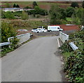
There are currently over 7.5m images from over14,400 individuals and you can help contribute to the project by visiting https://www.geograph.org.uk
Image Map
Images are licensed for reuse under creativecommons.org/licenses/by-sa/2.0
Notes
- Clicking on the map will re-center to the selected point.
- The higher the marker number, the further away the image location is from the centre of the postcode.
Image Listing (84 Images Found)
Images are licensed for reuse under creativecommons.org/licenses/by-sa/2.0
Image
Details
Distance
1
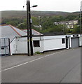
RDD Retail & Leisure Environments office near Wyndham
Alongside the unclassified road from Wyndham to Nantymoel.
Image: © Jaggery
Taken: 4 Oct 2018
0.01 miles
2
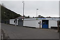
A S Construction office near Wyndham
Bespoke joinery & kitchen fitting business alongside the unclassified road from Wyndham to Nantymoel.
Image: © Jaggery
Taken: 4 Oct 2018
0.01 miles
3
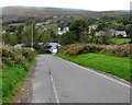
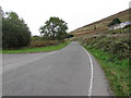
Road from Nantymoel towards Wyndham
Descending from the A4061 at the southern edge of Nantymoel into the valley of the Ogwr Fawr river.
Image: © Jaggery
Taken: 4 Oct 2018
0.01 miles
4
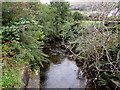
Downstream along the Ogwr Fawr, Wyndham
The river flows away from the camera on this https://www.geograph.org.uk/photo/6194261 road bridge.
Image: © Jaggery
Taken: 4 Oct 2018
0.04 miles
5
Road bridge over a river, Wyndham
Over the Ogwr Fawr river. Ahead for Price Town and Nantymoel.
Image: © Jaggery
Taken: 4 Oct 2018
0.04 miles
6
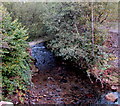
Upstream along the Ogwr Fawr, Wyndham
The river flows towards the camera on this https://www.geograph.org.uk/photo/6194261 road bridge.
Image: © Jaggery
Taken: 4 Oct 2018
0.05 miles
7
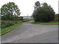
Junction between Wyndham and Nantymoel
On the left, the access road to Aber Field sports ground diverges from
the unclassified road ascending from Wyndham to the A4061 in Nantymoel.
Image: © Jaggery
Taken: 4 Oct 2018
0.06 miles
8

Wyndham and the lane from the A4061 Ogmore valley road
Cwm Ogwr (the Ogmore valley) is steep-sided but has several villages along its length.
Image: © Andrew Hill
Taken: 20 Oct 2008
0.08 miles
9
Access road to Aber Field sports ground, Nantymoel
From the north side of the unclassified road from Wyndham to the A4061 in Nantymoel.
Image: © Jaggery
Taken: 4 Oct 2018
0.08 miles
10
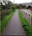
South along a combined footpath and cycleway, Wyndham
The former railway route is part of National Cycle Network Route 883
from Nantymoel to Blackmill. Ahead for Ogmore Vale and Blackmill.
Image: © Jaggery
Taken: 4 Oct 2018
0.08 miles