IMAGES TAKEN NEAR TO
Water Street, BRIDGEND, CF32 7AN
Introduction
This page details the photographs taken nearby to Water Street, CF32 7AN by members of the Geograph project.
The Geograph project started in 2005 with the aim of publishing, organising and preserving representative images for every square kilometre of Great Britain, Ireland and the Isle of Man.

There are currently over 7.5m images from over14,400 individuals and you can help contribute to the project by visiting https://www.geograph.org.uk
Image Map
Images are licensed for reuse under creativecommons.org/licenses/by-sa/2.0
Notes
- Clicking on the map will re-center to the selected point.
- The higher the marker number, the further away the image location is from the centre of the postcode.
Image Listing (87 Images Found)
Images are licensed for reuse under creativecommons.org/licenses/by-sa/2.0
Image
Details
Distance
1
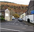
Water Street, Ogmore Vale
From the A4061 Bridge Street, Water Street leads to Riverside Garage and a footbridge over the Ogwr Fawr river.
Image: © Jaggery
Taken: 14 Nov 2018
0.00 miles
2
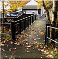
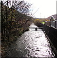
West across a river footbridge towards Water Street, Ogmore Vale
Near the bottom of these steps https://www.geograph.org.uk/photo/5974912 the footbridge crosses the Ogwr Fawr river. https://www.geograph.org.uk/photo/5974906
Image: © Jaggery
Taken: 14 Nov 2018
0.00 miles
3
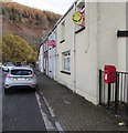
Queen Elizabeth II postbox, Water Street, Ogmore Vale
Water Street is a dead-end street on the east side of the A4061 Bridge Street.
It leads to a footbridge https://www.geograph.org.uk/photo/5974891 over the Ogwr Fawr river (ahead).
Image: © Jaggery
Taken: 14 Nov 2018
0.01 miles
4
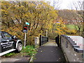
River footbridge at the eastern end of Water Street, Ogmore Vale
Across the Ogwr Fawr https://www.geograph.org.uk/photo/5974906
Image: © Jaggery
Taken: 14 Nov 2018
0.02 miles
5

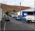
Riverside Garage, Water Street, Ogmore Vale
On the west bank of the Ogwr Fawr river.
Image: © Jaggery
Taken: 14 Nov 2018
0.02 miles
6
Downstream along the Ogwr Fawr, Ogmore Vale
Viewed from this footbridge https://www.geograph.org.uk/photo/5974891. The River Ogmore (Afon Ogwr in Welsh) has two major branches in its headwaters: the Ogwr Fawr which flows south through Nantymoel, Ogmore Vale and Lewistown and the Ogwr Fach which flows through Gilfach Goch. They join at Blackmill to form the River Ogmore/Afon Ogwr.
Image: © Jaggery
Taken: 14 Nov 2018
0.03 miles
7
West along Water Street, Ogmore Vale
Towards the A4061 Bridge Street. Riverside Garage https://www.geograph.org.uk/photo/5974883 is on the right.
Image: © Jaggery
Taken: 14 Nov 2018
0.03 miles
8
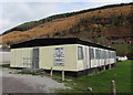
Rugby club changing rooms, Ogmore Vale
At the northern edge of this https://www.geograph.org.uk/photo/5975437 rugby pitch, the home ground of Ogmore Vale RFC.
Image: © Jaggery
Taken: 14 Nov 2018
0.03 miles
9
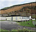
Ogmore Vale RFC changing rooms
Located near Bridge Street, this building is on the north side of Ogmore Vale rugby club's home ground.
Image: © Jaggery
Taken: 14 Nov 2018
0.03 miles
10
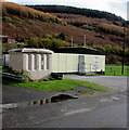
Water Street electricity substation, Ogmore Vale
Located 25 metres south of Water Street, the grey cabinet is a Western Power Distribution electricity substation. Its identifier is WATER STREET OGMORE VALE S/S 563719.
Image: © Jaggery
Taken: 14 Nov 2018
0.03 miles