1
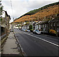
Row of houses, Bridge Street, Ogmore Vale
Viewed across the A4061 Bridge Street on the approach to the St John Street junction.
Image: © Jaggery
Taken: 25 Aug 2018
0.02 miles
2
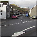
Bridge Street towards High Street, Ogmore Vale
Looking north along the A4061. The Corbett Arms https://www.geograph.org.uk/photo/5975139 is on the left.
Image: © Jaggery
Taken: 14 Nov 2018
0.02 miles
3
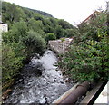
River Ogwr
View of Ogwr river from A4061 at Ogmore Vale.
Image: © Alan Hughes
Taken: 18 May 2017
0.02 miles
4
Row of stone houses, Bridge Street, Ogmore Vale
On the west side of the A4061 Bridge Street.
Houses in St John Street are in the background on the left.
Image: © Jaggery
Taken: 14 Nov 2018
0.02 miles
5
Downstream along the Ogmore, Ogmore Vale
The river flows to the SE away from Bridge Street in Ogmore Vale.
The River Ogmore here is also known as the Ogwr Fawr (Big Ogmore).
It joins the Ogwr Fach (Little Ogmore) at Blackmill.
Image: © Jaggery
Taken: 25 Aug 2018
0.02 miles
6
Tantastic, Bridge Street, Ogmore Vale
Tantastic tanning & beauty salon is next door to Cwm Ogwr Running Club.
Image: © Jaggery
Taken: 25 Aug 2018
0.02 miles
7
Junction of St John Street and Bridge Street, Ogmore Vale
The southern end of St John Street viewed across the A4061 Bridge Street.
Image: © Jaggery
Taken: 14 Nov 2018
0.03 miles
8
Bridge Street bus stop, Ogmore Vale
This stop on the A4061 Bridge Street is for buses to Bridgend via Blackmill.
Image: © Jaggery
Taken: 25 Aug 2018
0.03 miles
9
Junction of Bridge Street and St John Street, Ogmore Vale
Viewed across the A4061 Bridge Street. The Corbett Arms https://www.geograph.org.uk/photo/6040436 is on the left.
Image: © Jaggery
Taken: 25 Aug 2018
0.03 miles
10
Bridge Street flats, Ogmore Vale
On a bank of the River Ogmore (Ogwr Fawr).
Image: © Jaggery
Taken: 25 Aug 2018
0.03 miles


