IMAGES TAKEN NEAR TO
St. Brides Major, BRIDGEND, CF32 0SB
Introduction
This page details the photographs taken nearby to CF32 0SB by members of the Geograph project.
The Geograph project started in 2005 with the aim of publishing, organising and preserving representative images for every square kilometre of Great Britain, Ireland and the Isle of Man.

There are currently over 7.5m images from over14,400 individuals and you can help contribute to the project by visiting https://www.geograph.org.uk
Image Map
Images are licensed for reuse under creativecommons.org/licenses/by-sa/2.0
Notes
- Clicking on the map will re-center to the selected point.
- The higher the marker number, the further away the image location is from the centre of the postcode.
Image Listing (102 Images Found)
Images are licensed for reuse under creativecommons.org/licenses/by-sa/2.0
Image
Details
Distance
1
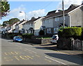
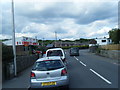
Ewenny Road semis, St Brides Major
Semi-detached houses on the east side of the B4265 Ewenny Road.
Image: © Jaggery
Taken: 4 Sep 2019
0.03 miles
2
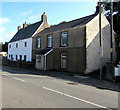
Dan-y-graig House and Belle Vue, Ewenny Road, St Brides Major
Dan-y-graig House is on the right. Coflein records that Belle Vue on the left was originally the Greyhound Inn, formerly a thatched-roof building. The building is shown on maps dating back to 1818.
Image: © Jaggery
Taken: 4 Sep 2019
0.04 miles
3
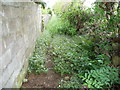
Overgrown footpath in St Brides Major
The ground has been disturbed which promotes growth of stinging nettles, not a great enhancement to any footpath.
Image: © Jeremy Bolwell
Taken: 10 Aug 2011
0.04 miles
4
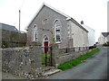
Bryn Sion chapel in St Brides Major
Despite its outward appearance being relatively unchanged this chapel has now been converted into a home. (The barbecue in the garden gave it away to me).
Image: © Jeremy Bolwell
Taken: 10 Aug 2011
0.06 miles
5
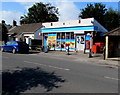
St Brides Major post office and shop
In September 2019 the village post office is inside this shop alongside the B4265 Ewenny Road.
Image: © Jaggery
Taken: 4 Sep 2019
0.07 miles
7
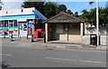
Little-used bus stop and shelter, Ewenny Road, St Brides Major
In September 2019 a notice in the shelter states that most buses through the village now use a different route - nearest bus stops are in Southerndown Road. The village post office is in the shop on the left. https://www.geograph.org.uk/photo/6256379
Image: © Jaggery
Taken: 4 Sep 2019
0.07 miles
8
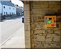
Yellow box on a bus shelter wall, Ewenny Road, St Brides Major
Inside this https://www.geograph.org.uk/photo/6256396 shelter. The box contains a defibrillator for use in a potentially life-threatening emergency. The defibrillator applies a therapeutic electric current to the chest or heart to stop irregular contractions, or fibrillation, of the heart.
Image: © Jaggery
Taken: 4 Sep 2019
0.07 miles
9
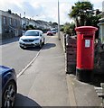
Queen Elizabeth II pillarbox, Ewenny Road, St Brides Major
Outside the village post office, behind the car here. https://www.geograph.org.uk/photo/6256379
Image: © Jaggery
Taken: 4 Sep 2019
0.07 miles
10
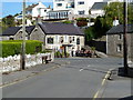
Fox and Hounds pub, St. Bride's Major
Image: © Ruth Sharville
Taken: 12 Sep 2010
0.07 miles