IMAGES TAKEN NEAR TO
Southerndown, BRIDGEND, CF32 0PY
Introduction
This page details the photographs taken nearby to CF32 0PY by members of the Geograph project.
The Geograph project started in 2005 with the aim of publishing, organising and preserving representative images for every square kilometre of Great Britain, Ireland and the Isle of Man.

There are currently over 7.5m images from over14,400 individuals and you can help contribute to the project by visiting https://www.geograph.org.uk
Image Map
Images are licensed for reuse under creativecommons.org/licenses/by-sa/2.0
Notes
- Clicking on the map will re-center to the selected point.
- The higher the marker number, the further away the image location is from the centre of the postcode.
Image Listing (47 Images Found)
Images are licensed for reuse under creativecommons.org/licenses/by-sa/2.0
Image
Details
Distance
1
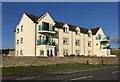
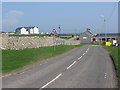
Little West apartments
Residential development opposite West Farm, Southerndown.
Image: © Alan Hughes
Taken: 27 Oct 2017
0.01 miles
2

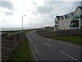
Apartments with sea views
A lovely position, but no doubt exposed to winds from the sea. Set on the B4524 between Ogmore by Sea and Southerndown.
Image: © Andrew Hill
Taken: 19 Oct 2008
0.02 miles
3
Apartments overlooking the sea near Southerndown
It can't be bad to look out on the ever changing seascape.
Image: © Jeremy Bolwell
Taken: 10 Aug 2011
0.03 miles
4
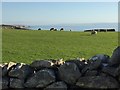
Sheep grazing in fields at Southerndown
In the distance:,the Glamorgan Heritage Coast towards Nash Point. Across the Bristol Channel the coast of North Somerset is visible through the haze.
Image: © Alan Hughes
Taken: 27 Oct 2017
0.05 miles
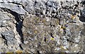
7
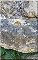
Ordnance Survey Rivet
This OS rivet can be found on the wall NE side of the road. It marks a point 57.409m above mean sea level.
Image: © Adrian Dust
Taken: 13 May 2018
0.08 miles
8
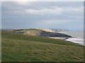
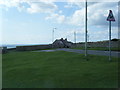
Coastal view near Southerndown
Signs warn walkers of the dangerous cliffs at the edge of the gently curving pastures. The sands of Dunraven Bay can be seen in the middle distance.
Image: © Andrew Hill
Taken: 19 Oct 2008
0.09 miles
9
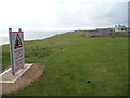
Warning signs on the clifftop on the Glamorgan Heritage Coast
Obvious you would think but it's easy to get too close. The cliffs here are very interesting with their crumbly sandstone, overhangs, caves, undercuts and you can find yourself wandering to the edge to get a certain shot or see a sea bird.
Image: © Jeremy Bolwell
Taken: 10 Aug 2011
0.09 miles
10
Ordnance Survey Cut Mark
This OS cut mark can be found on the wall NW side of the road. It marks a point 68.175m above mean sea level.
Image: © Adrian Dust
Taken: 13 May 2018
0.10 miles