IMAGES TAKEN NEAR TO
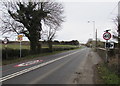
Wigfach, Laleston, BRIDGEND, CF32 0NL
Introduction
This page details the photographs taken nearby to CF32 0NL by members of the Geograph project.
The Geograph project started in 2005 with the aim of publishing, organising and preserving representative images for every square kilometre of Great Britain, Ireland and the Isle of Man.

There are currently over 7.5m images from over14,400 individuals and you can help contribute to the project by visiting https://www.geograph.org.uk
Image Map
Images are licensed for reuse under creativecommons.org/licenses/by-sa/2.0
Notes
- Clicking on the map will re-center to the selected point.
- The higher the marker number, the further away the image location is from the centre of the postcode.
Image Listing (24 Images Found)
Images are licensed for reuse under creativecommons.org/licenses/by-sa/2.0
Image
Details
Distance
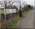
1
From 50 to 40 on Bridgend Road, Porthcawl
The 50mph speed limit on the A4106 Bridgend Road drops to 40mph.
Image: © Jaggery
Taken: 1 Apr 2016
0.02 miles
2
From 40 to 50 on Bridgend Road, Porthcawl
The 40mph speed limit on the A4106 Bridgend Road increases to 50mph.
Image: © Jaggery
Taken: 1 Apr 2016
0.02 miles
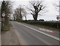
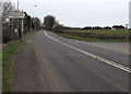
3
A4106 Bridgend Road looking towards Porthcawl.
Image: © Colin Pyle
Taken: 3 Dec 2009
0.03 miles
4
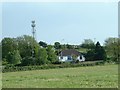
Cottage near the Nottage
Looking S from the lane towards the mast and cottage across the A4106
Image: © Chris Shaw
Taken: Unknown
0.03 miles
5
Bridgend Road telecoms cabinet in the outskirts of Porthcawl
Located 2½ miles from the centre of Porthcawl and 4 miles from Bridgend.
Image: © Jaggery
Taken: 1 Apr 2016
0.06 miles
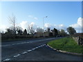
6
Turn right here for Porthcawl Civic Amenity Site
The sign facing the A4106 Bridgend Road points towards this http://www.geograph.org.uk/photo/5250433 unnamed road
to the civic amenity site (safle amwynderau dinesig in Welsh).
Image: © Jaggery
Taken: 1 Apr 2016
0.06 miles
7
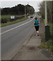
Jogging out of Porthcawl
A female jogger is on the pavement alongside the A4106 Bridgend Road in the outskirts of Porthcawl.
Image: © Jaggery
Taken: 1 Apr 2016
0.06 miles
8
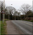
Z bends warning sign, Bridgend Road, Porthcawl
Facing the A4106 Bridgend Road in the outskirts of Porthcawl.
Image: © Jaggery
Taken: 1 Apr 2016
0.07 miles
9
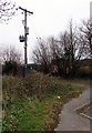
Electricity line spur pole and substation in the outskirts of Bridgend
The Western Power Distribution site is set back from the south side of the A4106 Bridgend Road.
The substation is the dark green cabinet http://www.geograph.org.uk/photo/5250465 in the background.
Image: © Jaggery
Taken: 1 Apr 2016
0.11 miles
10
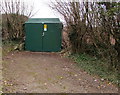
Western Power Distribution electricity substation near Bridgend Road, Porthcawl
Set back from the south side of the A4106 Bridgend Road. http://www.geograph.org.uk/photo/5250468
The substation identifier is DANYGRAIG SW SITE 56-4321.
Image: © Jaggery
Taken: 1 Apr 2016
0.11 miles