IMAGES TAKEN NEAR TO
Laleston, BRIDGEND, CF32 0HN
Introduction
This page details the photographs taken nearby to CF32 0HN by members of the Geograph project.
The Geograph project started in 2005 with the aim of publishing, organising and preserving representative images for every square kilometre of Great Britain, Ireland and the Isle of Man.

There are currently over 7.5m images from over14,400 individuals and you can help contribute to the project by visiting https://www.geograph.org.uk
Image Map
Images are licensed for reuse under creativecommons.org/licenses/by-sa/2.0
Notes
- Clicking on the map will re-center to the selected point.
- The higher the marker number, the further away the image location is from the centre of the postcode.
Image Listing (76 Images Found)
Images are licensed for reuse under creativecommons.org/licenses/by-sa/2.0
Image
Details
Distance
1
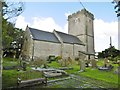
Laleston, St. David's
Parish church with Norman roots; the building dates from C14. Listed by CADW (Grade I).
Image: © Mike Faherty
Taken: 13 Jul 2016
0.03 miles
3
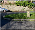
Millennium sundial, Laleston
On a small grass island at the southern end of Wind Street, near St David's Church and the village post office. Presented by Laleston WI (Women's Institute) in 2000 to commemorate the Millennium.
http://www.geograph.org.uk/photo/4317033 to the top of the sundial.
Image: © Jaggery
Taken: 24 Dec 2014
0.03 miles
4
Top of the Millennium sundial, Laleston
Located here. http://www.geograph.org.uk/photo/4317030
Image: © Jaggery
Taken: 24 Dec 2014
0.03 miles
5
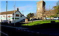
Village Post Office & Store and Church, Laleston
Viewed across the A473 High Street on a sunny Christmas Eve 2014. The church is St David's.
Image: © Jaggery
Taken: 24 Dec 2014
0.03 miles
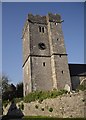
6
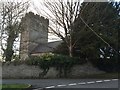
Laleston Church
St.David's Church, Laleston.
Image: © Alan Hughes
Taken: 10 Feb 2016
0.04 miles
7
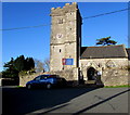
South side of St David's Church Laleston
The name board shows The Parish Church of St David Laleston,
Parish of Laleston with Tythegston in the Church in Wales Diocese of Llandaff.
Image: © Jaggery
Taken: 24 Dec 2014
0.04 miles
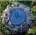
8
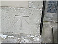
Ordnance Survey Cut Mark
This OS cut mark can be found on the south face of St David's Church. It marks a point 62.454m above mean sea level.
Image: © Adrian Dust
Taken: 4 May 2015
0.04 miles
9

High Street houses in Laleston
Looking east towards the former Oystercatcher pub. http://www.geograph.org.uk/photo/4290016
Image: © Jaggery
Taken: 24 Dec 2014
0.04 miles
10

X4 Cymru Clipper in Laleston
On the A473 High Street Laleston, a First bus on route X4 to Neath via Pyle
and Port Talbot passes the Heol Trelales junction. The First website states
Cymru Clipper is the new name for longer distance bus services in South and West Wales. Cymru Clipper raises the standards on First Cymru's bus services which link the region's principal towns and cities.
To make your journey easier and more comfortable, services are run with many brand new, easy access buses to assist customers with mobility problems and parents with small children in pushchairs.
Image: © Jaggery
Taken: 24 Dec 2014
0.04 miles