IMAGES TAKEN NEAR TO
High Street, BRIDGEND, CF32 0HL
Introduction
This page details the photographs taken nearby to High Street, CF32 0HL by members of the Geograph project.
The Geograph project started in 2005 with the aim of publishing, organising and preserving representative images for every square kilometre of Great Britain, Ireland and the Isle of Man.

There are currently over 7.5m images from over14,400 individuals and you can help contribute to the project by visiting https://www.geograph.org.uk
Image Map
Images are licensed for reuse under creativecommons.org/licenses/by-sa/2.0
Notes
- Clicking on the map will re-center to the selected point.
- The higher the marker number, the further away the image location is from the centre of the postcode.
Image Listing (65 Images Found)
Images are licensed for reuse under creativecommons.org/licenses/by-sa/2.0
Image
Details
Distance
2
Former Horeb Welsh Presbyterian Church in Laleston
Viewed across High Street in December 2014 when there is a SOLD notice on the wall of the Grade II listed former Horeb Welsh Presbyterian Church, built in 1831. A Google Earth Street View taken in June 2011 shows a Bridgend Christian Church nameboard here.
Image: © Jaggery
Taken: 24 Dec 2014
0.03 miles
3

The Bridgend Circular Walk at Laleston
This is a view at the northern end of the field seen in Image The A473 lies a very short distance beyond the gate. The gate, incidentally, is a single unit/2-in-1 field gate and pedestrian gate. There are a number of these in the area.
Image: © eswales
Taken: 24 Aug 2021
0.07 miles
4
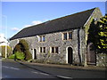
Village Farm House, Laleston
The core of this house is thought to be seventeenth century.
Image: © Chris Andrews
Taken: 26 Mar 2015
0.08 miles
5
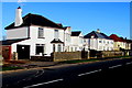
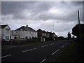
White houses in Laleston
On the north side of the A473 High Street near the eastern edge of the village.
Image: © Jaggery
Taken: 24 Dec 2014
0.08 miles
6
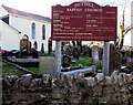
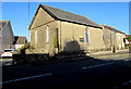
Bethel Baptist Church nameboard and churchyard, Laleston
The church http://www.geograph.org.uk/photo/4290017 is set back from the south side of High Street.
Image: © Jaggery
Taken: 24 Dec 2014
0.08 miles
7
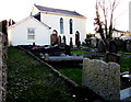
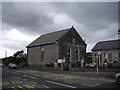
Bethel Baptist Church, Laleston
Set back from the south side of High Street.
Image: © Jaggery
Taken: 24 Dec 2014
0.08 miles
8
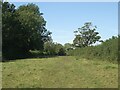
A field on the Bridgend Circular Walk, Laleston
When walking northwards on the Bridgend Circular Walk, this is the last field passed through before the A473 in Laleston is reached. There are some fine mature deciduous trees on its western boundary.
Image] looks in the opposite direction along some of the field.
Image: © eswales
Taken: 24 Aug 2021
0.08 miles
9

The former Oystercatcher pub in Laleston
Viewed across High Street in December 2014. Text on the wall shows CIRCA 1824 and A Warm Welcome to All Our Customers Old & New, but there is no welcome here now. The pub shut several years ago.
Image: © Jaggery
Taken: 24 Dec 2014
0.09 miles