IMAGES TAKEN NEAR TO
Llangewydd, BRIDGEND, CF32 0EU
Introduction
This page details the photographs taken nearby to CF32 0EU by members of the Geograph project.
The Geograph project started in 2005 with the aim of publishing, organising and preserving representative images for every square kilometre of Great Britain, Ireland and the Isle of Man.

There are currently over 7.5m images from over14,400 individuals and you can help contribute to the project by visiting https://www.geograph.org.uk
Image Map
Images are licensed for reuse under creativecommons.org/licenses/by-sa/2.0
Notes
- Clicking on the map will re-center to the selected point.
- The higher the marker number, the further away the image location is from the centre of the postcode.
Image Listing (3 Images Found)
Images are licensed for reuse under creativecommons.org/licenses/by-sa/2.0
Image
Details
Distance
1
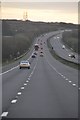
Bridgend District : The M4 Motorway
The M4 Motorway heading westbound through the Bridgend area.
Image: © Lewis Clarke
Taken: 10 Apr 2014
0.20 miles
2
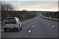
Bridgend District : The M4 Motorway
The M4 Motorway heading westbound through the Bridgend area.
Image: © Lewis Clarke
Taken: 10 Apr 2014
0.23 miles
3
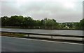
M4 at crossing point with minor road
Looking south from westbound M4 carriageway where motorway crosses minor road from Cefn Cross to Llangewydd.
Image: © Clint Mann
Taken: 25 Aug 2014
0.24 miles